Events such as Ash Wednesday in Victoria and South Australia in the 1980s, Black Saturday in Victoria in 2009 and the enduring 2001 Black Christmas in NSW, resulted in hundreds of lives lost and close to 5,000 homes destroyed. These are just three examples of a long list of major Australian bushfire events.

As we head towards 2050, climate change is predicted to cause fire seasons to start earlier, end later and involve more frequent extremes of weather that support major loss events. More than ever before, planning and preparation is playing a significant role in mitigating major bushfires and their effects on lives, properties and infrastructure.
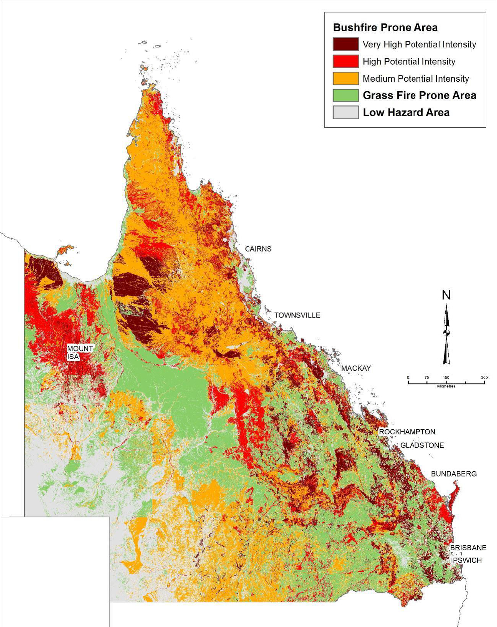
We developed mapping technology that identified bushfire prone areas in Queensland down to a 25 metre square area. Our researchers have now stepped onto the international stage by mapping regions all over the world that have conditions susceptible to fire events. This latest global tool is a valuable resource for hazard analysts, financers, developers and even the general public, seeking bushfire information online.
Thinking global when it comes to natural disasters
Our bushfire urban design researchers have developed the bushfire hazard module for the World Bank’s ThinkHazard! website. It identifies areas that may be subject to natural disasters in a proposed development project area and makes recommendations on ways to reduce their impact.
The global site enables users to search a country, state or region and identify if a particular hazard, such as tsunami, flood, volcano or earthquake, has the potential to cause loss, damage or disruption to a development project in the area.
Applying the lessons learnt in Australia can help others internationally when it comes to the understanding and mitigating bushfire impacts. There's lots of information that is now available online about floods, fire and other hazards but it's not always easily accessible and not generally in the same place. Besides giving location specific advice, ThinkHazard! provides links to additional resources such as local risk assessment approaches and highlights how each hazard may change in the future as a result of climate change.
It took the team about six months to collate and build the bushfire information system, which was largely based on the probability of experiencing weather conditions that could support a fire ignition and spread. However the search results are not always what people might expect.
Some regions identified as high fire danger areas in ThinkHazard! typically have little to no vegetation to actually burn. While the really obvious arid zones such as the Sahara and Simpson Desert have been removed from the ThinkHazard! wildfire mapping, there are many areas adjacent to deserts that are arid most of the time. When these arid regions experience unusually high rainfall it can lead to extensive grasslands which can later dry out and provide a wildfire risk. This includes Central Australia near the Simpson Desert, and sub-Saharan Africa, which both have high fire danger readings.
The ThinkHazard! wildfire mapping methodology has limitations due to its reliance on broad scale global weather datasets. However our approaches to mapping wildfire hazard within Australia can been more sophisticated and data intensive.
Applying knowledge in Australia
The team have also developed a series of state-wide mapping products for Queensland, identifying the most bushfire prone areas. This methodology determines bushfire hazards based on the potential intensity of a severe bushfire, which involves assessment of fire weather severity, fuel availability and topography. This is a useful indicator of areas where building loss could be expected and helps planners to design and locate buildings based on the likely level of fire severity in a particular location.
The Bushfire Prone Area mapping has now been widely adopted by local governments. It is also being used to prioritise areas for community engagement, landscape risk treatment and insurance risk profiling.

Using knowledge and online tools to embrace shared responsibility
Online tools like the mapping for Queensland and ThinkHazard!, those that incorporate advanced mapping knowledge and technology, are emerging as essential resources for people requiring accurate and detailed information to understand, plan and prepare for the possibility of fire.
Online mapping tools and warning systems are also becoming prevalent as a way to issue targeted warnings before and during fire events.
Computers are faster, online mapping tools are easier and more sophisticated and the data is more accurate and more easily accessible, which means the systems are improving rapidly and will continue to do so.
The tools are not only essential for fire authorities but also for the general public by enabling people to get more of this information and helping them build this information into their own personal bushfire planning.
Events such as Ash Wednesday in Victoria and South Australia in the 1980s, Black Saturday in Victoria in 2009 and the enduring 2001 Black Christmas in NSW, resulted in hundreds of lives lost and close to 5,000 homes destroyed. These are just three examples of a long list of major Australian bushfire events.
As we head towards 2050, climate change is predicted to cause fire seasons to start earlier, end later and involve more frequent extremes of weather that support major loss events. More than ever before, planning and preparation is playing a significant role in mitigating major bushfires and their effects on lives, properties and infrastructure.
We developed mapping technology that identified bushfire prone areas in Queensland down to a 25 metre square area. Our researchers have now stepped onto the international stage by mapping regions all over the world that have conditions susceptible to fire events. This latest global tool is a valuable resource for hazard analysts, financers, developers and even the general public, seeking bushfire information online.
Thinking global when it comes to natural disasters
Our bushfire urban design researchers have developed the bushfire hazard module for the World Bank’s ThinkHazard! website. It identifies areas that may be subject to natural disasters in a proposed development project area and makes recommendations on ways to reduce their impact.
The global site enables users to search a country, state or region and identify if a particular hazard, such as tsunami, flood, volcano or earthquake, has the potential to cause loss, damage or disruption to a development project in the area.
Applying the lessons learnt in Australia can help others internationally when it comes to the understanding and mitigating bushfire impacts. There's lots of information that is now available online about floods, fire and other hazards but it's not always easily accessible and not generally in the same place. Besides giving location specific advice, ThinkHazard! provides links to additional resources such as local risk assessment approaches and highlights how each hazard may change in the future as a result of climate change.
It took the team about six months to collate and build the bushfire information system, which was largely based on the probability of experiencing weather conditions that could support a fire ignition and spread. However the search results are not always what people might expect.
Some regions identified as high fire danger areas in ThinkHazard! typically have little to no vegetation to actually burn. While the really obvious arid zones such as the Sahara and Simpson Desert have been removed from the ThinkHazard! wildfire mapping, there are many areas adjacent to deserts that are arid most of the time. When these arid regions experience unusually high rainfall it can lead to extensive grasslands which can later dry out and provide a wildfire risk. This includes Central Australia near the Simpson Desert, and sub-Saharan Africa, which both have high fire danger readings.
The ThinkHazard! wildfire mapping methodology has limitations due to its reliance on broad scale global weather datasets. However our approaches to mapping wildfire hazard within Australia can been more sophisticated and data intensive.
Applying knowledge in Australia
The team have also developed a series of state-wide mapping products for Queensland, identifying the most bushfire prone areas. This methodology determines bushfire hazards based on the potential intensity of a severe bushfire, which involves assessment of fire weather severity, fuel availability and topography. This is a useful indicator of areas where building loss could be expected and helps planners to design and locate buildings based on the likely level of fire severity in a particular location.
The Bushfire Prone Area mapping has now been widely adopted by local governments. It is also being used to prioritise areas for community engagement, landscape risk treatment and insurance risk profiling.
Using knowledge and online tools to embrace shared responsibility
Online tools like the mapping for Queensland and ThinkHazard!, those that incorporate advanced mapping knowledge and technology, are emerging as essential resources for people requiring accurate and detailed information to understand, plan and prepare for the possibility of fire.
Online mapping tools and warning systems are also becoming prevalent as a way to issue targeted warnings before and during fire events.
Computers are faster, online mapping tools are easier and more sophisticated and the data is more accurate and more easily accessible, which means the systems are improving rapidly and will continue to do so.
The tools are not only essential for fire authorities but also for the general public by enabling people to get more of this information and helping them build this information into their own personal bushfire planning.