Murray-Darling Basin Sustainable Yields Project
Overview
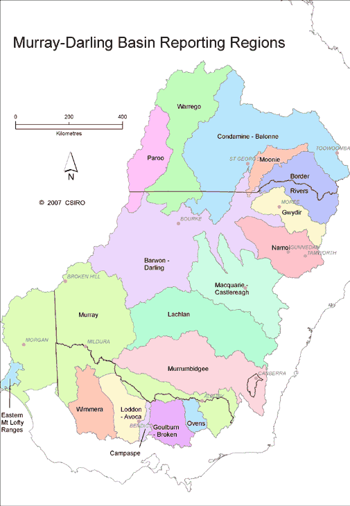
The regions covered by the Murray-Darling Basin Sustainable Yields Project
A basin-scale investigation into water availability in the Murray-Darling Basin and the impacts of development, water extraction and climate.
We have completed a series of reports which assessed current and future water availability in the Murray-Darling Basin.
In 2007 and 2008, the Murray-Darling Basin Sustainable Yields Project assessed the likely impacts of climate change on the surface water and groundwater resources of the Murray-Darling Basin.
This region covers one million square kilometres and supplies at least 40 per cent of the national’s agricultural production.
- catchment development
- changing groundwater extraction
- climate variability
- climate change
The Murray-Darling Basin Sustainable Yields Project delivered the most comprehensive and complex whole-of-basin water assessment ever undertaken in Australia.
The final publications include a whole-of Basin report and comprehensive results for each of the 18 regions in the Murray-Darling Basin.
Water availability in the Murray-Darling basin: a report from CSIRO to the Australian Government (CSIRO Research Publications Repository).
Final reports
Final reports from the project including whole-of-Basin and regional results. These reports are stored in the CSIRO Research Publications Repository.
Whole of Basin reports:
Released on 24 November 2008, the whole of basin report summarises the assessments for the 18 regions in the Basin.
A summary of lessons learnt from the assessment:
Regional reports:
Murray region
- Water availability in the Murray. A report to the Australian Government from the CSIRO Murray-Darling Basin Sustainable Yields Project
- Summary: Water availability in the Murray
Murrumbidgee region
- Water availability in the Murrumbidgee. A report to the Australian Government from the CSIRO Murray-Darling Basin Sustainable Yields Project
- Summary: Water availability in the Murrumbidgee
Moonie region
- Water availability in the Moonie. A report to the Australian Government from the CSIRO Murray-Darling Basin Sustainable Yields Project
- Summary: Water availability in the Moonie
Loddon-Avoca region
- Water availability in the Loddon-Avoca. A report to the Australian Government from the CSIRO Murray-Darling Basin Sustainable Yields Project
- Summary: Water availability in the Loddon-Avoca
Macquarie-Castlereagh region
- Water availability in the Macquarie-Castlereagh. A report to the Australian Government from the CSIRO Murray-Darling Basin Sustainable Yields Project
- Summary: Water availability in the Macquarie-Castlereagh
Lachlan region
- Water availability in the Lachlan. A report to the Australian Government from the CSIRO Murray-Darling Basin Sustainable Yields Project
- Summary: Water availability in the Lachlan
Namoi region
- Water availability in the Namoi. A report to the Australian Government from the CSIRO Murray-Darling Basin Sustainable Yields Project
- Summary: Water availability in the Namoi
Barwon-Darling region
Ovens region
Gwydir region
Border Rivers region
Paroo region
Wimmera region
Warrego region
Terms of reference
Includes the deliverables and reporting requirements of the project.
On 7 November 2006, the Prime Minister of Australia, the State Premiers of New South Wales, Victoria and South Australia, and the Acting Premier of Queensland, commissioned the consultant to ‘report progressively by the end of 2007 on sustainable yields of surface and groundwater systems within the Murray Darling Basin, including an examination of assumptions about sustainable yields in light of changes in climate and other issues’.
There are three main deliverables:
1. Development of a transparent, consistent and robust methodology for determining the extent of available water resources in each major catchment/aquifer, and the Murray Darling Basin (MDB) as a whole, including guidance on:
- how to adjust the historic flow records used in surface water models and the recharge assumptions used in groundwater models, to factor in climate change and other risks
- how to address the interaction between surface and groundwater systems
- identifying significant knowledge and information gaps
2. Application of the above methodology to estimate the quantity and temporal distribution of the water resources that are available in each major catchment/aquifer, and the Basin as a whole, having made any necessary adjustments to assumptions about climate or other risks.
- comparison of the new estimates of water resources with those identified as necessary to meet the levels of extractive use (current entitlements, security of supply and actual use) and to achieve the stated environmental and other public benefit outcomes of existing water sharing plans
- if there are catchments or aquifers within the Basin either without current water sharing plans or with plans for which environmental outcomes and/or levels of extractive use are not clear, these parameters will be inferred where possible using existing information (such as State water policies or existing regional NRM plans) and any assumptions clearly stated.
3. Application of the above methodology to estimate water availability and demand 20 years into the future in the light of climate change and other risks
- comparison of the new estimates of future water resources with those identified as necessary to meet the levels of extractive use (current entitlements, security of supply and actual use) and to achieve the stated environmental and other public benefit outcomes of existing water sharing plans.
Reporting
Three levels of reporting were envisaged as follows:
1. Single page summary sheets that provide a graphical and tabulated summary of the predicted relative changes in water security and other indicators in the context of historical changes in water availability. These summaries will be produced for the entire basins and for each modelled catchment and are intended for non-technical audiences.
2. Overview reports of ten pages or less (for the entire basin and each modelled catchment) that provide:
- contextual information regarding use availability and use in the area
- a summary of the assessed changes in surface water security; groundwater resource indicators and environmental flow indicators
- interpretative text that outline the potential implications of the results for the catchment.
3. Technical appendices that provide for each reporting area all the supporting detailed technical results including time series plots, flow durations curves, allocation reliability diagrams and statistical analyses.
These reports:
- are likely to be large (50–100 pages per catchment) and intended for a technical audience
- will provide a complete legacy of the technical work of the project and provide the underpinning information on which the defensibility of the summarised results
- will fully document the audit trail of data and models which are used to produce the quantitative assessments of water availability and supply reliability.
Project Methods
Includes the aims of the project and a description of the four climate and water resource development scenarios considered and modelled.
Overview:
Overview of project methods. A report to the Australian Government from the CSIRO Murray-Darling Basin Sustainable Yields Project (CSIRO Research Publications Repository)
Aims:
The project’s aims were to:
- define major catchments for the Murray-Darling Basin (MDB) based on surface water catchments and existing river system models
- assess, catchment by catchment, the severity of drought for the last five, seven and ten years
- define four different scenarios of climate and water resource development for modelling current and future water availability
- model the surface runoff and groundwater recharge patterns for each defined catchment under each defined scenario
- assess the implications of the changes in runoff, recharge and water resource development, on water availability in each defined catchment under each defined scenario using the river system and groundwater models used by state agencies for water resource planning (and other models where necessary)
- assess the implications of potential changes in water availability on diversion volumes (and their reliability), environmental flows and on the likely ability to meet the stated aims of current water sharing plans, assuming current water sharing arrangements
- report results progressively – catchment by catchment, and finally for the entire MDB.
Scenarios considered:
The four scenarios of climate and water resource development that were considered are broadly defined as follows:
- Current development and historic climate as used in current water sharing plans and associated models. This is generally the full available historic hydrologic record (typically 1895–2006) and the water resource development (land use, farm dams, infrastructure, diversion/abstraction levels) described by recent data sets. This is the baseline scenario against which other scenarios are compared.
- Current development and recent climate to assess the consequences of a continuation of the climate of the last ten years. Development conditions are as for baseline. The climate series are generated by using the average climate conditions for the last ten years to adjust historic daily climate records. Climate variability is considered by statistically generating 100 climate series and analysing three of these: a low-end, the middle and a high-end scenario from the full range.
- Current development and future climate to assess the consequences of climate change. This uses predictions for the climate in 2030 from global climate models from the 4th Assessment Report of the Intergovernmental Panel on Climate Change. Multiple model projections are considered for low, medium and high levels of global warming.
- Future development and future climate to assess the combined consequences of climate change and changes in land/water use. The future climate scenarios are as described for (3) above. The considerations of future development vary region by region, and are limited by current predictive ability and the time constraints of the project. Two aspects of catchment development that affect system inflows and can be reasonably modelled are the expansion of farm dams and plantation forestry. These aspects of development will be considered in collaboration with State agencies and with reference to current State policies. Detailed assessments of future increases in bushfire frequency and the resultant impacts on catchment water yield cannot be reliably made. However, a synoptic assessment of the likely magnitude and locations of bushfire impacts on catchment water yield will be made. Growth in groundwater extraction up to the currently imposed extraction limits will also be considered in the development scenario. The many other aspects that may affect future water availability and use, for example:
- changed water use by native vegetation under altered atmospheric carbon dioxide concentrations
- changes in on-farm and off-farm water use efficiency
- water trading
- new water infrastructure
- are currently impossible to reliably predict and are thus beyond the scope of the project
Modelling:
Each of the four scenarios were described by 112 year sequences of modelled daily climate data. For the historic climate, historic data were used with gaps in the records filled using statistical modelling. For the recent climate scenario these data were statistically generated based on historic data.
For future climate results for high, medium and low emission runs of the global climate models used in the 4th Assessment Report of the Intergovernmental Panel on Climate Change (IPCC) were analysed and used to estimate future seasonal rainfalls, average temperatures and potential evapotranspiration.
A regional climate model was also run to estimate future statistical distributions of daily rainfall, season by season. The results from the global and regional climate models were then used to adjust the historic climate series to provide simulated future climate series that adhere to the historic sequencing of climate. Maintaining historic sequencing information enables sensible comparisons between scenarios.
The climate data were used to model daily surface runoff on 5 km x 5 km grids across each catchment, and to model daily groundwater recharge at point locations for separate aquifers. The climate and runoff data were used to adjust the inputs to river system models (that include models of agricultural and urban water demand) to determine:
- daily river flows
- reservoir levels
- diversions to water users in each catchment for each scenario assuming current water sharing arrangements.
Recharge data were input to groundwater system models to determine water table levels for major aquifers for each scenario.
For minor aquifers simpler assessments were made of likely changes in water levels without undertaking numerical modelling.
Assessments were made of the exchanges between rivers and underlying aquifers. Where these exchanges were large, estimates of flow loss/gain were passed from the river model to the groundwater model, and from the groundwater model back to rerun the river model to adjust the modelled flow losses/gains.
A statistical assessment of the recent drought was made catchment by catchment and for the whole MDB based on rainfall and river flow observations for the previous five, seven and ten years compared to the full historical instrumental record.
An assessment of the uncertainty associated with the results was undertaken by considering the uncertainty of future climate and future water resource development and the uncertainty associated with the climate and hydrologic models used. Independent assessments of catchment water balances were made using remotely sensed estimates of evapotranspiration; typically, 90 per cent of rainfall is evaporated or transpired by plants (forests, grassland and crops), while only around 10 per cent becomes runoff. These estimates were compared to observed and modelled runoff and river flow.
Based on the range of modelling, water availability across each region and under each scenario is reported. This included reporting a range of measures of reservoir storage volumes, water diversion reliability and groundwater use. Measures were reported that indicate the potential for environmental impacts associated with current and future surface and groundwater availability.
Technical Publications
As part of the CSIRO Murray-Darling Basin Sustainable Yields Project, a series of technical reports focusing on different aspects of the science were released. They combine information from across the Murray-Darling Basin into a basin-wide assessment.
These technical reports are stored in the CSIRO Research Publications Repository:
- Background report on the Great Artesian Basin
- Climate data for hydrologic scenario modelling in the Murray-Darling Basin
- Data Management for the Murray-Darling Basin Sustainable Yields Project Report
- Diffuse groundwater recharge modelling across the Murray-Darling Basin
- Estimating open water evaporation for the Murray-Darling Basin
- Groundwater management unit prioritisation and assessment ranking
- Mid-Murrumbidgee Groundwater Model Calibration
- Modelling surface–groundwater interactions
- Rainfall-runoff modelling across the Murray Darling Basin
- Characterisation of recent rainfall and runoff in the Murray-Darling Basin
- River water balance accounts across the Murray-Darling Basin, 1990–2006
- Southern Riverine Plains groundwater model calibration in the Murray-Darling Basin
- Surface–groundwater connectivity assessment
- Upper Condamine groundwater model calibration
- Upper Lachlan groundwater model calibration
- Upper Murrumbidgee IQQM calibration
- Water balance estimates from satellite observations over the Murray-Darling Basin