
Launched late last month, the NSW Spatial Digital Twin will improve the state’s infrastructure, services, and economy.
The Digital Twin will enable planners, policymakers and developers to make more informed decisions and reduce costs by creating new efficiencies, explained the Minister for Customer Service NSW, Victor Dominello, at the Sydney-held event.
“With this technology, it changes everything,” he said in his address.
“It opens up data to grow the NSW economy. The genius of Digital Twin is that it’s opened and shared, so we can share ideas using this great platform, and when you share ideas, you generate progress, you generate innovation, and you generate the good for the people of our state.”
“You can actually own the future with Digital Twin because you can see it.”
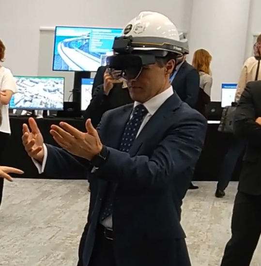
Open to stakeholders, industry leaders and the media, the launch saw the Minister take part in an augmented reality demonstration of Fort Denison using Data61’s HoloLens 2 technology, a preface of the next stage of Digital Twin development - the ability to visualise Twins in-situ.
Guests and delegates were also able to experience an additional augmented reality demonstration, with HoloPins being used as markers of data and signage, only visible to individuals wearing a HoloLens. One HoloPin showed the electricity usage of the event room, a second directed HoloLens wearers to the nearest exit, and a third displayed the water and electrical pipes in a support pole - each representing the kinds of data found in the Digital Twin
| What are Digital Twins?
Digital Twins create virtual replicas of small and large-scale physical objects, buildings, cities, regions and systems, a technology game-changer for the future of smart cities.
The NSW Spatial Digital Twin is a powerful interactive live data sharing, collaboration and visualisation tool accessible from an Internet browser, which captures 3D and 4D spatial data to model the urban environment.
The tool aggregates high-value transport, infrastructure, property, planning and environmental datasets directly from governments, industry and other data owners, as well as from other digital twins and geographic systems.
This previously inaccessible data is then federated to ensure that all users are working off the same authoritative data, allowing them to effectively respond to different built and natural environments.
The NSW Spatial Digital Twin allows users to interact with a virtual replica of the Western Sydney region, adding and removing layers to visualise data and infrastructure, such as:
- Under- and above- ground utilities
- Live transport data
- Roads, schools and hospitals
- Building materials
- Property boundaries and valuations
- Strata plans
- 3D trees
- Any relevant data fed into the system
The Digital Twin is also secure and private by design, meaning that only users with the correct permissions can see certain datasets, a key component to maintain the privacy of sensitive assets, such as underground utilities.
| How can the Digital Twin be used?
The NSW Spatial Digital Twin can be used by planners, infrastructure owners, developers, policymakers and residents, to help better plan, design and manage our cities. By viewing this data collectively, rather than in isolation, users are empowered to make data-driven decisions to create better, smarter cities, and plan for Australia’s future.
By layering different datasets on top of each other, organisations and governments can gain a broader understanding of current landscapes, and the kinds of impacts any changes, such as new developments, might have on local communities.
For example, if a developer wanted to build a residential tower, they could view the nearby infrastructure and determine if it can support new residents in the area. They could also see where the tower’s shadow would fall on surrounding areas during the day, and whether there might be any underground assets that could be affected by construction, such as water and sewer pipes.
This level of data sharing could also allow for community consultation on new development applications, and potentially assist in planning, prevention and recovery support from natural disasters such as flooding.
Digital twins can also be incorporated into augmented or virtual reality systems, allowing those in building and construction to visualise in-situ how a construction project might look, including the building height, construction materials used, and energy output.
| Our Digital Twin capabilities
Digital Twins are scalable technologies, meaning they can be applied on a large city/regional scope, down to a building/infrastructure level, and even further down to a small object level. Data61 holds a strong track record in the development of such technologies at each different level of scale:
Cities and Regions
Spark
Spark is an award-winning open framework for bushfire prediction and analysis, which takes our current knowledge of fire behaviour and combines it with state-of-the-art simulation science to produce predictions, statistics and visualisations of bushfire spread.
It can also be used for land management and planning, fire mitigation analysis, real-time fire prediction and analysis of fire events. Spark can read weather data from meteorological forecasts and use this information directly within fire models. Geographic information, such as land slope, vegetation and un-burnable areas, such as roads and water bodies, also affect the spread of the fire. Spark allows users to easily incorporate such environmental data and to use this information to define a fire spread rate.
UrbanMonitorUrbanMonitor is an observation system that can track and communicate land cover and structural changes in a way that has not been previously possible. UrbanMonitor can examine changes in these surfaces at high precision (e.g. 0.1 to 0.3m) – their presence, area, condition, volume and height above the ground or above sea level. To achieve this, the data is geometrically and radiometrically calibrated making quantitative comparisons in space and time possible
Predicting and managing traffic congestionIn partnership with Transport NSW, Data61 developed an artificial intelligence (AI) engine to predict traffic congestion across Sydney. It ingests transport datasets for the training of special purpose predictive models, forming a closed loop with simulation models to continuously train the AI engine with new situations and responses while calibrating the simulation model. Scientific fundamentals of the AI engine have been thoroughly tested using both historical and real-time transport datasets, such as smart card (Opal), GPS, and traffic signal data.
This work is contributing to the delivery of the next generation congestion management system for the NSW Transport Management Centre (TMC), with the system enhancing the capability to predict two hours into the future and act in five minutes, which is likely to lead to significant improvements in efficiently managing traffic flows.
Urban Augmented Reality
Researchers at Data61's Immersive Environments Lab in Canberra have developed key technologies for Urban Augmented Reality, to improve both productivity and safety by 'inserting' digital information directly into the physical world.
The ‘HoloPin’ platform, as demonstrated at the NSW Digital Twin launch, enables entire buildings to be holographically augmented with digital twin data. Live and historic data from smart sensors (such as fine-grained energy meters) can be displayed within the physical environment. Smart glasses running the service can also uncover x-ray views into wall cavities for maintenance, display 3D annotations and work orders for maintenance and construction, or reveal the latest locations of mobile assets.
Infrastructure
Monitoring the health of structuresWe have developed structural health monitoring technology using sensors, bespoke machine-learning based predictive analytics and distributed processing capabilities to enable maintenance scheduling based on the condition of assets, increasing efficiency and extending their service life.
We have used this approach to help the NSW Roads and Maritime Services with monitoring the Sydney Harbour Bridge road deck, with 2,400 sensors collecting information on the road condition to provide early warning before affecting bridge users.
Objects
Mixed Reality LabOur state-of-the-art Mixed Reality Lab enables manufacturing and multiple other industries to create Digital Twins of real-world objects. Located in Clayton, the lab houses a set-up of industrial and consumer optical cameras and sensing equipment to capture detailed information about a physical object and the space surrounding it. The equipment is underpinned by sophisticated algorithms (Workspace) which merge the enormous amounts of data collected to create a digital twin in a matter of minutes.
The lab is a unique combination of Data61’s research expertise across machine learning, computer vision, computational modelling, IoT, and CSIRO’s patented Stereo Depth Fusion technology for depth estimation.
3D SLAM Our 3D SLAM mobile mapping technology allows direct real-time 3D capture data of built and natural environments, which can be utilised for analysis, synthesis, decision-making, manufacturing, and more.
This award-winning technology is the world’s first continuous-time SLAM algorithm, where the trajectory is correctly modelled as a continuous function of time. This rigorous formulation has allowed us to lead the market in mobile mapping and producing the world’s first hand-held mobile mapping system and 3D spinning lidar system based on passive actuation.
BLEAT Bluetooth Low Energy Aware Tracking (BLEAT) offers a low cost, low maintenance, long term solution capable of room level accuracy tracking of people and objects moving throughout various infrastructure.
This offers dramatic opportunities for productivity improvement (time lost locating objects and people), advanced health and safety (knowledge of people remaining during evacuations, real-time alerting to staff and customers of location specific hazards) and unprecedented knowledge of infrastructure utilisation through analytics (which can be used for optimising planning, maintenance, cleaning, building etc.).