Management through measurement
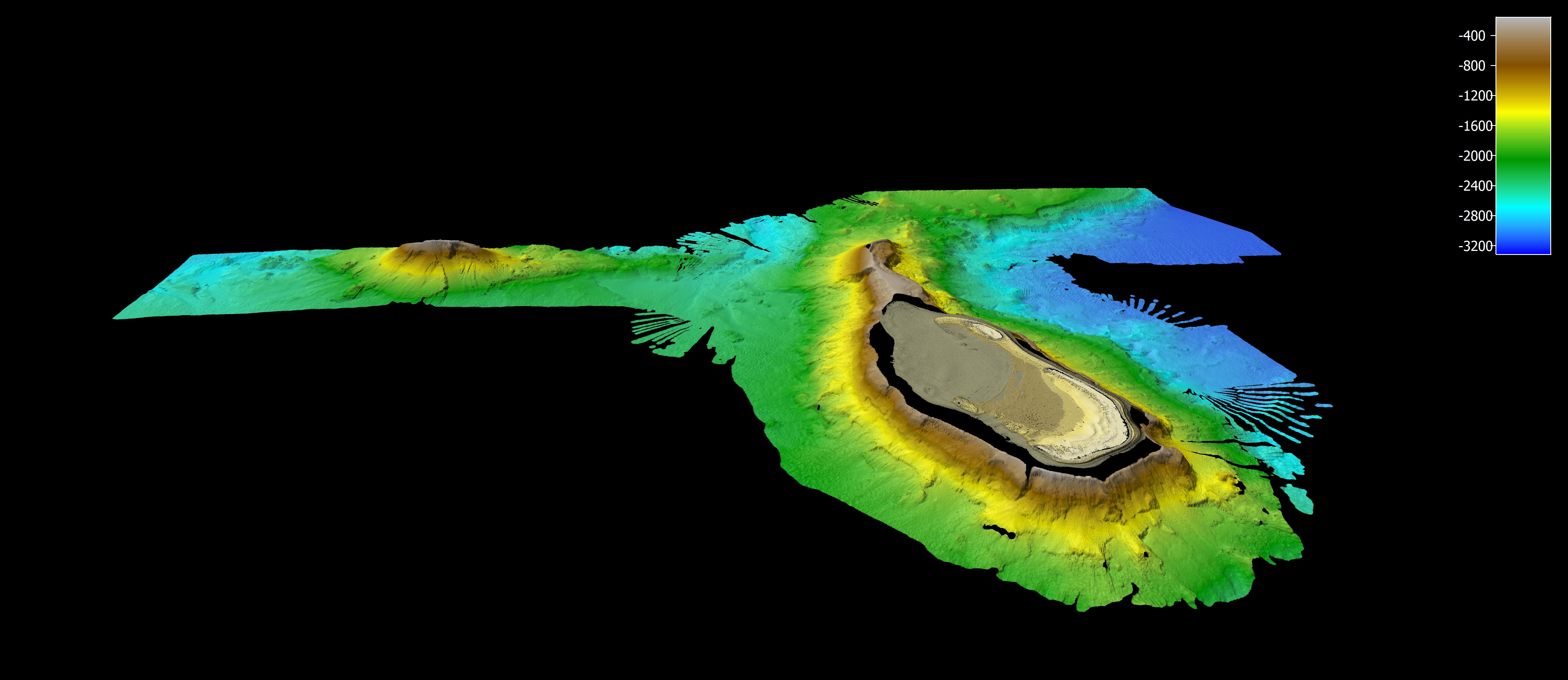
Much of Australia's vast ocean territory is unknown, with only 38.5% of it mapped to a modern standard. There is an extensive array of advanced geophysical instrumentation on research vessel (RV) Investigator that allows bathymetric, biological and geophysical data to be collected in 3D and faster than ever before. The combination of systems allows high quality and quantity data to be collected from any ocean depth in our marine estate, from shallow coastal regions to full ocean depth.
RV Investigator's three seafloor mapping systems are permanently housed in the vessel's gondola, a wing-like structure suspended beneath the hull that is designed to minimise acoustic interference and ensure best performance from these systems. The vessel also has two drop keels, which carry an array of scientific instruments.
All datasets collected on voyage are made accessible for the benefit of researchers, resource managers and other decision-makers to better inform the conservation and management of Australia's marine estate. As well as making this data publicly accessible, we also contribute to both national and international programs, including AusSeabed and the AODN Portal.
Key equipment and capabilities
RV Investigator is equipped with a range of fixed and portable acoustic equipment. Housed in the vessel gondola are three multibeam echosounders, a sub-bottom profiler, and a multibeam water column bio-acoustic echosounder. Further acoustic equipment is housed in vessel’s drop-keels or can be added to meet voyage research needs.
Multibeam echosounders
RV Investigator has three different discrete multibeam echosounders (MBES) which are permanently mounted in the vessel's gondola: Kongsberg EM124, Kongsberg EM712 and Kongsberg EM2040 MKII systems.
The Kongsberg EM124 is a deep-water bathymetry and backscatter system, which performs best from 300-400 m to full ocean depth. The area of seafloor mapped in a single pass can be up to six times the water depth, delivering a strip (swath) up to 40 km wide at full ocean depth.
The Kongsberg EM712 is designed for acquiring high-resolution, relatively shallow bathymetry and backscatter data on the continental shelf. It performs best to 600-700 m depth but can work to a maximum depth of 2000 m.
The Kongsberg EM2040 MKII is a wideband ultra-high resolution system used to capture bathymetry and backscatter in shallow water up to 600 m.
Geophysical equipment
A Sub-Bottom Profiler (SBP) on the gondola can be used to investigate the thickness and composition of the sediments and rocks that make up the seabed to depths exceeding 200 m below the seafloor, depending on sediment type. The SBP can be operated in conjunction with the multibeam and other systems.
A gyroscopically stablised gravity meter is in the centre of the vessel and used to measure variations in the Earth's gravitational field.
Bio-acoustic equipment
The vessel has a suite of bio-acoustic equipment for fisheries and biological research. This consists of a scientific echosounder for estimating fish and plankton abundance, a high definition fish finding sonar for finding and identifying fish, and a scientific multibeam echosounder for water column analysis.
A Simrad EK80 single-beam scientific echo sounder can be used to target many different fish species for biomass estimation in the water column.
A fish finding sonar is designed to locate a range of fish including those located near the surface and close to the bottom without the need for passing over the fish.
A Simrad ME70 scientific multibeam echosounder located in the gondola combines the large and flexible sampling volume of the multibeam swath with the accuracy of the quantitative scientific echo sounder. This system spreads a signal in a fan shape to 120 degrees, collecting data to 500 m depth and 3000 m wide.
Access the data
The Marine National Facility provides specialist support on each voyage to operate on board systems and process, interpret and visualise bathymetric, biological and geophysical datasets.
Find out more about our data products.
Management through measurement
Much of Australia's vast ocean territory is unknown, with only 38.5% of it mapped to a modern standard. There is an extensive array of advanced geophysical instrumentation on research vessel (RV) Investigator that allows bathymetric, biological and geophysical data to be collected in 3D and faster than ever before. The combination of systems allows high quality and quantity data to be collected from any ocean depth in our marine estate, from shallow coastal regions to full ocean depth.
RV Investigator's three seafloor mapping systems are permanently housed in the vessel's gondola, a wing-like structure suspended beneath the hull that is designed to minimise acoustic interference and ensure best performance from these systems. The vessel also has two drop keels, which carry an array of scientific instruments.
All datasets collected on voyage are made accessible for the benefit of researchers, resource managers and other decision-makers to better inform the conservation and management of Australia's marine estate. As well as making this data publicly accessible, we also contribute to both national and international programs, including AusSeabed and the AODN Portal.
Key equipment and capabilities
RV Investigator is equipped with a range of fixed and portable acoustic equipment. Housed in the vessel gondola are three multibeam echosounders, a sub-bottom profiler, and a multibeam water column bio-acoustic echosounder. Further acoustic equipment is housed in vessel’s drop-keels or can be added to meet voyage research needs.
Multibeam echosounders
RV Investigator has three different discrete multibeam echosounders (MBES) which are permanently mounted in the vessel's gondola: Kongsberg EM124, Kongsberg EM712 and Kongsberg EM2040 MKII systems.
The Kongsberg EM124 is a deep-water bathymetry and backscatter system, which performs best from 300-400 m to full ocean depth. The area of seafloor mapped in a single pass can be up to six times the water depth, delivering a strip (swath) up to 40 km wide at full ocean depth.
The Kongsberg EM712 is designed for acquiring high-resolution, relatively shallow bathymetry and backscatter data on the continental shelf. It performs best to 600-700 m depth but can work to a maximum depth of 2000 m.
The Kongsberg EM2040 MKII is a wideband ultra-high resolution system used to capture bathymetry and backscatter in shallow water up to 600 m.
Geophysical equipment
A Sub-Bottom Profiler (SBP) on the gondola can be used to investigate the thickness and composition of the sediments and rocks that make up the seabed to depths exceeding 200 m below the seafloor, depending on sediment type. The SBP can be operated in conjunction with the multibeam and other systems.
A gyroscopically stablised gravity meter is in the centre of the vessel and used to measure variations in the Earth's gravitational field.
Bio-acoustic equipment
The vessel has a suite of bio-acoustic equipment for fisheries and biological research. This consists of a scientific echosounder for estimating fish and plankton abundance, a high definition fish finding sonar for finding and identifying fish, and a scientific multibeam echosounder for water column analysis.
A Simrad EK80 single-beam scientific echo sounder can be used to target many different fish species for biomass estimation in the water column.
A fish finding sonar is designed to locate a range of fish including those located near the surface and close to the bottom without the need for passing over the fish.
A Simrad ME70 scientific multibeam echosounder located in the gondola combines the large and flexible sampling volume of the multibeam swath with the accuracy of the quantitative scientific echo sounder. This system spreads a signal in a fan shape to 120 degrees, collecting data to 500 m depth and 3000 m wide.
Access the data
The Marine National Facility provides specialist support on each voyage to operate on board systems and process, interpret and visualise bathymetric, biological and geophysical datasets.
Find out more about our data products.