Our Crace site, centred on the historic Gungahlin Homestead, is home to ecosystems focused research including the Australian National Wildlife Collection.
Share
Description and plan (including name and location)Block 348 U.P. No. 5834, Gungahlin
Street Address: Bellenden Street, Crace, ACT, 2911
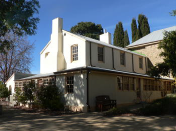
Building 001 – Gungahlin Homestead
Building 003 – Canteen
Building 024 – Laundry House Meeting Room
Discrete heritage place identification number for each place
Place ID: 105434
Place File No: 8/01/000/0048
Details of ownership or other tenure arrangements
The site is currently leased by CSIRO. CSIRO has control of the site and is therefore responsible for heritage management.
Summary description of any significant physical characteristics and elements of the place
The following features are considered intrinsic to the significance of the Gungahlin Homestead Precinct:
Buildings 1, 3 & 24 individually and as a group.
Wall and roof cladding, Buildings 3 & 24.
Original windows and doors, Buildings 1, 3 & 24.
Main staircase in Building 1, 1860 and 1880 wings.
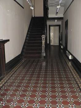
Tiled floor to Building 1, entry hall and verandah.
Cedar skirtings, architraves, door and window frames and door leaves in Building 1.
Profiled ceiling in Building 1 entry hall.
T&G profiled timber ceilings to 1860 and 1880 verandahs Building 1.
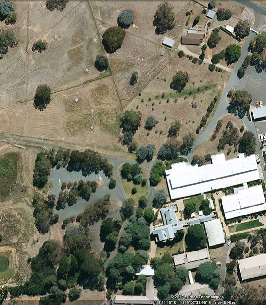
Original carriageway and trees.
Courtyard space between Buildings 1, 3, 24 & 45 as an open space.
Original plaster and batten ceilings in Building 1.
The exotic trees of the driveway and adjacent to the east and south of Buildings 1 and 7.
The rural character of the site, setting for Gungahlin Homestead.
Sequential summary of the use of the place
1828 – 1914: Private individuals for construction/occupancy of residence and farming of land etc
1915 – 1949: Commonwealth Government resumed land and leased to private individuals for occupancy of residence and farming of land etc.
1949 – 1953: Department of Interior gave property to Canberra University College for use as a residence for diplomatic cadets.
1953 – 2014: CSIRO.
2015 – Current: CSIRO staff and external tenant.
Statement of significance, identifying heritage values and specifying any that are Commonwealth Heritage Values
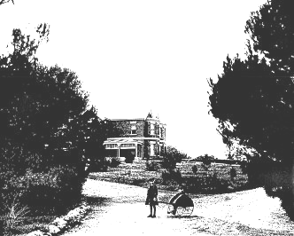
Gungahlin is a former pastoral property homestead landscape that has been adapted for use as a scientific wildlife research station. It comprises a complex of buildings, a carriage way and carriage loop with tree plantings, former garden areas, and former paddocks with dams and water race remnant. It is important for its ability to convey a history of rural property living within its current use as a national research station, encompassing major changes of homestead architecture resulting from economic booms.
The 1862-65 rendered brick Georgian style northern section of the homestead, including interior detailing along with remaining historic outbuildings, the dam north of the carriageway that connects to the water race, all constructed during the property ownership of William Davis Jnr, portray the first major phase of rural property development.
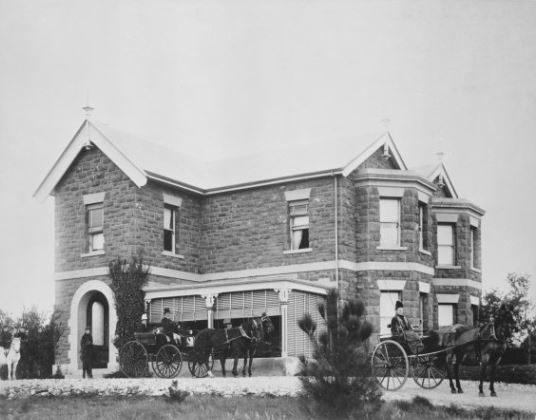
The grand sandstone Victorian style addition of 1883 that transformed the homestead complex into a rural mansion with fine interior detailing, a carriage way and carriage loop, demonstrates a period of economic rural prosperity during the ownership of Edward Crace. (Criterion A4) Australian Historic Themes: 3.9 Farming for Commercial Profit.
Gungahlin is important for its association with Federation, being one of three imposing rural mansions estates (along with Duntroon and Yarralumla) acquired by the Federal Government to provide for national institutions during a period when the Federal Government had limited funding for development. As with Duntroon and Yarralumla the complex retains the frontage and presence of the historic rural mansion as the focal feature of the building complex. (Criterion A4) Australian historic Themes: 4.3, Developing Institutions, 7.4 Federating Australia.
The Gungahlin complex is one of a few two-storey late 19th century country estates of the pre-Canberra rural district that remains and demonstrates periods of rural prosperity and comfort in its scale and style. (Criterion B2)
The former homestead building including interior details exhibits the Victorian Georgian styles in the early northern section and a simplified Victorian Tudor style in the southern sandstone addition. The curving carriage way and tear drop shaped carriage loop leading to the homestead on a rise are typical of the picturesque rural estate layout. The choice of trees from the various period plantings, the spatial arrangement and style of the historic outbuildings and choice of fabric, all demonstrate typical period styles form eras of development. (Criterion D2)
The former homestead with its double bay windows, ashlar rough cut stone work, location on natural rise, is a visual focal feature which is enhanced by the approach along the former carriage bay now enclosed by suckering elms. (Criterion E1)
The sandstone wing of the homestead, believed to have been designed by John Gregory Crace is acknowledged for its period design style and interior detailing. The spatial arrangement of the nineteenth century structures with nearby twentieth century laboratory buildings has been mostly successfully achieved by building layouts that respect the building configuration of historic outbuildings around a courtyard, and by their low rise form which do not conflict with the focal feature importance of the historic homestead. The exception is the Laboratory Research Support building which extends beyond the eastern front of the homestead and impacts the carriage loop. (Criterion F1)
The complex has a strong association with nineteenth century rural families Davis and Crace and the long term lessee J F Watson, all important in the local community. (Criterion H1)
A record of any other heritage listings
Also on former National Heritage List and National Trust of Australia (ACT) Register of Classified Places.
Dates and natures of any works, maintenance or other activity that is relevant to conservation of heritage values
Ref 2014 Heritage Management Plan for history of site and building changes.
Property or information access restrictions/requirements
The site is currently occupied by CSIRO and external tenants. Access is limited and must be arranged through CSIRO Business and Infrastructure Services. For access to this premises, please e-mail PropertyManager@csiro.au.
Consultation requirements relating to the place
Formal consultation occurred during public consultation phase of finalising the 2014 Heritage Management Plan. No other consultation occurred.
Relevant conservation documents or references
2014 Heritage Management Plan prepared by Eric Martin & Associates – supersedes previous Heritage Management Plans.
Records of any objects that are significant by association with the place, indicating their current location and/or archived records of particular importance to the heritage values of the place
None known.
Description and plan (including name and location)Block 348 U.P. No. 5834, Gungahlin
Gungahlin homestead c1890
Street Address: Bellenden Street, Crace, ACT, 2911
Building 001 – Gungahlin Homestead
Building 003 – Canteen
Building 024 – Laundry House Meeting Room
Discrete heritage place identification number for each place
Place ID: 105434
Place File No: 8/01/000/0048
Details of ownership or other tenure arrangements
The site is currently leased by CSIRO. CSIRO has control of the site and is therefore responsible for heritage management.
Summary description of any significant physical characteristics and elements of the place
The following features are considered intrinsic to the significance of the Gungahlin Homestead Precinct:
Buildings 1, 3 & 24 individually and as a group.
Wall and roof cladding, Buildings 3 & 24.
Original windows and doors, Buildings 1, 3 & 24.
Main staircase in Building 1, 1860 and 1880 wings.
Tiled floor to Building 1, entry hall and verandah.
Cedar skirtings, architraves, door and window frames and door leaves in Building 1.
Profiled ceiling in Building 1 entry hall.
T&G profiled timber ceilings to 1860 and 1880 verandahs Building 1.
Original carriageway and trees.
Courtyard space between Buildings 1, 3, 24 & 45 as an open space.
Original plaster and batten ceilings in Building 1.
The exotic trees of the driveway and adjacent to the east and south of Buildings 1 and 7.
The rural character of the site, setting for Gungahlin Homestead.
Sequential summary of the use of the place
1828 – 1914: Private individuals for construction/occupancy of residence and farming of land etc
1915 – 1949: Commonwealth Government resumed land and leased to private individuals for occupancy of residence and farming of land etc.
1949 – 1953: Department of Interior gave property to Canberra University College for use as a residence for diplomatic cadets.
1953 – 2014: CSIRO.
2015 – Current: CSIRO staff and external tenant.
Statement of significance, identifying heritage values and specifying any that are Commonwealth Heritage Values
Gungahlin is a former pastoral property homestead landscape that has been adapted for use as a scientific wildlife research station. It comprises a complex of buildings, a carriage way and carriage loop with tree plantings, former garden areas, and former paddocks with dams and water race remnant. It is important for its ability to convey a history of rural property living within its current use as a national research station, encompassing major changes of homestead architecture resulting from economic booms.
The 1862-65 rendered brick Georgian style northern section of the homestead, including interior detailing along with remaining historic outbuildings, the dam north of the carriageway that connects to the water race, all constructed during the property ownership of William Davis Jnr, portray the first major phase of rural property development.
The grand sandstone Victorian style addition of 1883 that transformed the homestead complex into a rural mansion with fine interior detailing, a carriage way and carriage loop, demonstrates a period of economic rural prosperity during the ownership of Edward Crace. (Criterion A4) Australian Historic Themes: 3.9 Farming for Commercial Profit.
Gungahlin is important for its association with Federation, being one of three imposing rural mansions estates (along with Duntroon and Yarralumla) acquired by the Federal Government to provide for national institutions during a period when the Federal Government had limited funding for development. As with Duntroon and Yarralumla the complex retains the frontage and presence of the historic rural mansion as the focal feature of the building complex. (Criterion A4) Australian historic Themes: 4.3, Developing Institutions, 7.4 Federating Australia.
The Gungahlin complex is one of a few two-storey late 19th century country estates of the pre-Canberra rural district that remains and demonstrates periods of rural prosperity and comfort in its scale and style. (Criterion B2)
The former homestead building including interior details exhibits the Victorian Georgian styles in the early northern section and a simplified Victorian Tudor style in the southern sandstone addition. The curving carriage way and tear drop shaped carriage loop leading to the homestead on a rise are typical of the picturesque rural estate layout. The choice of trees from the various period plantings, the spatial arrangement and style of the historic outbuildings and choice of fabric, all demonstrate typical period styles form eras of development. (Criterion D2)
The former homestead with its double bay windows, ashlar rough cut stone work, location on natural rise, is a visual focal feature which is enhanced by the approach along the former carriage bay now enclosed by suckering elms. (Criterion E1)
The sandstone wing of the homestead, believed to have been designed by John Gregory Crace is acknowledged for its period design style and interior detailing. The spatial arrangement of the nineteenth century structures with nearby twentieth century laboratory buildings has been mostly successfully achieved by building layouts that respect the building configuration of historic outbuildings around a courtyard, and by their low rise form which do not conflict with the focal feature importance of the historic homestead. The exception is the Laboratory Research Support building which extends beyond the eastern front of the homestead and impacts the carriage loop. (Criterion F1)
The complex has a strong association with nineteenth century rural families Davis and Crace and the long term lessee J F Watson, all important in the local community. (Criterion H1)
A record of any other heritage listings
Also on former National Heritage List and National Trust of Australia (ACT) Register of Classified Places.
Dates and natures of any works, maintenance or other activity that is relevant to conservation of heritage values
Ref 2014 Heritage Management Plan for history of site and building changes.
Property or information access restrictions/requirements
The site is currently occupied by CSIRO and external tenants. Access is limited and must be arranged through CSIRO Business and Infrastructure Services. For access to this premises, please e-mail PropertyManager@csiro.au.
Consultation requirements relating to the place
Formal consultation occurred during public consultation phase of finalising the 2014 Heritage Management Plan. No other consultation occurred.
Relevant conservation documents or references
2014 Heritage Management Plan prepared by Eric Martin & Associates – supersedes previous Heritage Management Plans.
Records of any objects that are significant by association with the place, indicating their current location and/or archived records of particular importance to the heritage values of the place
None known.
Contact us
Find out how we can help you and your business. Get in touch using the form below and our experts will get in contact soon!
CSIRO will handle your personal information in accordance with the Privacy Act 1988 (Cth) and our Privacy Policy.
We have received your enquiry and will reply soon.
We're Sorry
The contact form is currently unavailable. Please try again later. If this problem persists, please call us with your enquiry on 1300 363 400 or +61 3 9545 2176. We are available from 9.00 am to 4.00 pm AEST Monday - Friday.
 Block 348 U.P. No. 5834, Gungahlin
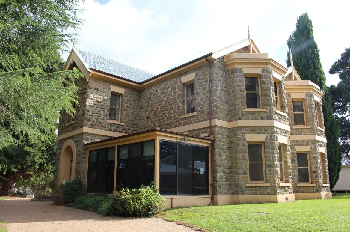
 estead architecture resulting from economic booms.