New research has examined over 100 years of historical data on Murray-Darling Basin ecosystems to provide an indication of long-term trends in the Basin’s ecological condition.
In the 1890s, a series of levees were constructed along the banks of the central region of the River Murray, disconnecting the river from its floodplains and wetlands—including the Barmah-Millewa Forest and its magnificent stands of river red gums. By 1936, the Hume Dam had been completed on the Murray, east of Albury, and other rivers in the southern Basin—the Murrumbidgee, Goulburn, Lachlan and Campaspe—had dams and weirs constructed on the upper reaches.
The intent of all this river regulation was to protect properties from uncontrolled flooding and to consolidate water resources for irrigation, providing some degree of protection from drought. The side effect was the permanent alteration of the flow and flood regimes of the rivers and floodplains. There was death of river red gums in those areas that became near-permanently inundated, and a loss of habitat for waterbirds, fishes and other species that were dependent on almost annual winter-spring floods—the floods could last up to six months, fed by meltwaters from the Snowy Mountains and the Victorian Alps.
There are similar stories elsewhere. Since the arrival of European settlers, the lands and waters of the Murray-Darling Basin have been subject to major environmental change—first from sheep and cattle grazing during the Pastoral Era, then gold mining, timber harvesting from the river red gum forests, depletion of fish stocks by commercial fisheries, land clearing by selectors for cropping, and finally the establishment of irrigation districts and the diversion of water from the rivers to grow fruit, vegetables, grapes, rice and cotton.
Other environmental changes included the introduction of exotic weeds and pest animals, erosion and runoff from pastures and cropland, salinity from land clearing and, to improve navigation, the ‘de-snagging’ of tens of thousands of dead river red gums from the beds of the Murray and Murrumbidgee, permanently altering sediment and carbon dynamics and removing fish habitat.
Between the 1950s and 1980s, storage and diversions of the Murray-Darling Basin’s water resources increased sharply. By the 1990s, the over-allocation of water resources led to a cap on diversions and the recognition of the need for an environmental water entitlement. By then, the frequency, duration and extent of high flows and floods had been reduced, and many rivers, floodplains and wetlands were generally in poor ecological condition. The evidence on the Basin’s condition is compiled in the Murray Darling Basin Authority’s Sustainable Rivers Audits.
As a consequence of all these changes, there is broad scientific consensus that flow-dependent ecosystems in the Basin are in a bad way. But this, in itself, is not new—most Australians are familiar with the concept that the Basin is in poor condition. The other part of the prevailing narrative is that the condition of the Basin is continuing to decline, primarily due to altered river flows following river regulation and increases in irrigation water diversions from 1950-1980, compounded by droughts.
However, knowing the current condition status of particular ecosystems in the Basin does not tell us how the ecological condition is changing over time. To reveal information on trends, data from long-term monitoring are required, over periods sufficiently long to account for the fluctuations of the system; its 'boom and bust' years of flood and drought.
In search of a trend
An Australian research team, including researchers from CSIRO and Macquarie University, set out to examine long-term ecological monitoring data for the Basin to determine if they supported the prevailing narrative of decline. Their first finding was that no published long-term data on trends have been fully collated and analysed at the whole-of-Basin scale. The two Sustainable Rivers Audits (2004-2007 and 2008-2012) are the nearest thing we have to that. And the long-term data that exists have never been examined systematically.
So they took on the job, statistically analysing a trove of publicly-available, historical data dating from 1905 up to 2013. The results were published today in Marine & Freshwater Research.
"We collated and analysed over 300 published long-term ecological time series data to find out what they could tell us about ecosystem condition in the Murray-Darling Basin," said CSIRO’s Dr Matthew Colloff, the lead author of the study.
“As far as we are aware, this is the first time this kind of data has been synthesised for an entire river basin.”
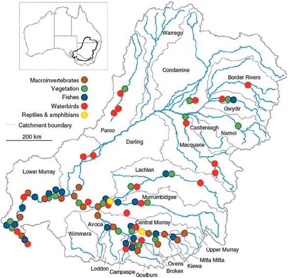
Time series data are those that are collected in a consistent way over a period of years in order to elucidate a trend. The time series analysed in this study covered vegetation condition and extent, and the occurrence, or population estimates, of reptiles and amphibians, aquatic macroinvertebrates (such as dragonflies, water-beetles and snails), fishes and waterbirds. The minimum time series duration was five years and the average was 23 years. The longest time series was 104 years’ worth of data on breeding events of Australian pelican at the Coorong.
The results of their analysis were surprising.
“We were expecting that the majority of individual time series would show quite significant declines over time, but while there are declines during droughts and recoveries after flood events, the predominant pattern is one of stability over time,” said Dr Colloff.
“The only result that reflected a small but significant declining trend was in the population data. However, we are conscious that this is a statistical trend and are in the process of determining whether it is ecologically meaningful.”
Considering the poor condition of so many of the Basin’s rivers and floodplains, and the absence of declining trends for ecological time series (most of which commence after 1980), the researchers suggested these ecosystems may have been in this state for a considerable length of time. This led them to hypothesise that environmental changes brought about by European settlers since the 1840s have so transformed ecosystems from their natural state that, by the time any of the data used in this study was collected, the structure, functions and biotic composition of these ecosystems had been permanently altered. And so these ecosystems have remained, relatively stable and fluctuating, at the low end of historically much higher ranges.
Further, historical stressors may have played a greater role in ecosystem condition than previously allowed for by the dominant narrative. That is, while alterations to river flows and flood regimes stemming from increases in irrigation water diversions from the 1950s has contributed to poor ecosystem condition, it is only one of the more recent drivers of change. This needs to be considered along with historical impacts from grazing, mining, timber harvesting, over-fishing, land clearing, erosion, salinity and repeated droughts over a period of 175 years.
After the flood
By looking more closely at the data from during and after the Millennium Drought (1997-2009), the authors found many specific examples of species with a decline and recovery pattern, indicative of cycles of 'boom and bust'. However, they also found evidence that there were ‘winners’ and ‘losers’ among the species they examined. That is, some species recovered well following extensive and prolonged flooding and high water flows in 2010 and 2011 but others did not. This indicates that some species may require more than one cycle of flooding in order for recovery to occur.
Over time, and with climate change likely to deliver more frequent and prolonged droughts, there may be localised extinctions of the ‘losers’, and a shift towards species that are more tolerant of a wide range of ecological disturbances.
Implications for future monitoring and management
The authors consider that their data synthesis lays the groundwork for a better understanding of ecosystem change in the Murray-Darling Basin and for the collection of more useful trend data into the future. The study also identifies some areas in need of attention.
They collated and analysed a wide variety of data from the southern Basin, in particular the River Murray and Coorong estuary, but because of a lack of available data, they were unable to include the Avoca, Castlereagh, Kiewa, Warrego and Wimmera catchments in the analysis. As a result, some species have been well represented and others have not.
Further, as most of the time series focused on a particular species at a particular location, they were unable to infer anything about long-term changes in the extent of wetlands, or changes in their suitability as habitat. This sort of data is not yet available at a whole-of-Basin scale.
These sorts of knowledge gaps could be addressed by more long-term monitoring across the Murray-Darling Basin. Dr Colloff says this is something that can be done better, even with limited resources.
“There are some really simple things that can be done to improve the collection of long-term data,” said Dr Colloff. “The effort required to design better monitoring programs is slight compared with the effort of actually collecting the data.”
“With appropriate statistical modelling and analysis, monitoring can be designed to accommodate limited resources, providing fewer but better data with long term continuity and comparability in mind.”
The authors hope that their work will contribute to a more systems-focused approach to monitoring on a Basin-wide scale, so that the ecological responses to changes in water flows can be more clearly and easily assessed in the future.
More information
- Colloff, Matthew J., Caley, Peter, Saintilan, Neil, Pollino, Carmel A., and Crossman, Neville D. (2015). Long-term ecological trends of flow-dependent ecosystems in a major regulated river basin. Marine and Freshwater Research, http://dx.doi.org/10.1071/MF14067
- For an environmental history of changes to floodplains, wetlands and rivers of the Murray-Darling Basin since European Settlement, see: Colloff, Matthew J. (2014) Flooded Forest and Desert Creek: Ecology and History of the River Red Gum. CSIRO Publishing.
- Murray Darling Basin Authority, Sustainable Rivers Audits