EIGHTEEN months ago a group of scientists started tagging and tracking Straw-necked Ibis in the Murray-Darling Basin.
At the time, they knew that more effective environmental water management depended on better knowledge about the movements of these birds.
What they didn’t expect was that the ibis would become more than dots on a map or the basis of integral research – they would become story-tellers, as unique individuals with their own experiences, adventures and lessons to learn.
This year, this collection of stories has increased with GPS satellite transmitters having tracked 40 straw-necked Ibis, 15 Royal Spoonbills and five Australian White Ibis.
On any given day, the researchers can tell you that Royal Spoonbill “Elvis” is still active and foraging in the wetlands in the Barmah-Millewa area, or that “Eric” the juvenile has moved from Lake Cargelligo to an irrigated property 20 kilometres west of Condobolin.
“Yes, we name them. With so many birds on the move, it is much easier to remember a name than an 8-digit leg band number, and they have different personalities,” project leader Dr Heather McGinness says.
“We want to know where they go, when and why. We are following their movements every hour of every day.”
The CSIRO-led project is the largest GPS satellite tracking movement study that’s ever been done in Australia on large waterbirds.
Part of the waterbird theme of the Murray-Darling Basin Environmental Water Knowledge and Research Project (MDB EWKR), the ibis and spoonbill research aims to fill some important knowledge gaps.
With all the investment across the Murray-Darling Basin in environmental water management, often partly for the benefit of waterbird species that are in decline, water managers and policy makers want to know where the birds are flying, eating and breeding, and how to improve their survival rates. But up until now there’s been no knowledge of the routes these birds take when moving between breeding events, or how water management interacts with other factors such as predation, weather extremes and food abundance to influence their survival.
New and exciting data
The satellite GPS tracking of the movements of individual birds across the Murray-Darling Basin is producing amazing maps, some with accompanying photos of the birds being tracked.
The method has revealed startling results.
In the space of a single year, one adult male Straw-necked Ibis tracked from the Macquarie Marshes travelled a total of 3,665 km. An adult female from the same place travelled 3,217 km. Both of these birds travelled long distances in summer and autumn but ‘settled down’ over winter at one place. Some Straw-necked Ibis have travelled from Victoria to Queensland in just a few days.
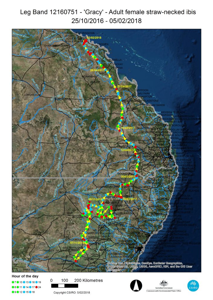
Several Straw-necked Ibis have used the same route up and down the Murray-Darling Basin at different times, and certain sites have been used by multiple birds or repeatedly by the same birds on their travels. The satellite-tracking has also highlighted the importance of large roosting trees for these species, providing a safe place to sleep at night away from predators and protected from bad weather, but close to good feeding areas. All of this information helps with targeting management actions for the benefit of the birds.
The importance of water
Water managers and policy-makers are becoming increasingly conscious of the need to manage both feeding and breeding areas for both adult and juvenile waterbirds. Appropriately managing environmental water placement and timing is critical to facilitating the recruitment of juveniles into our waterbird populations and ultimately species survival.
“Many species of waterbirds are completely dependent on big flood events to breed. They need widespread flooding across very large areas and it needs to be of long duration. Water is the absolute number one crucial thing. It’s what drives their decisions,” McGinness says.
The future
While still in progress, preliminary results from the satellite tracking, which will continue until mid-2019, have already advanced knowledge of previously poorly understood ibis and spoonbill movement and population patterns and trends in Australia.
Research teams are also working on-ground in nesting sites, quantifying the development, diet, energy needs and survival of chicks, and the influence of threats like predation and water level changes. To do this they are counting nests, chicks and eggs every two weeks, conducting drone surveys at peak breeding times, collecting feather, scat and regurgitate samples, and using remote motion-sensing and time-lapse nest cameras to monitor nests and over time, which produce stunning photographs.
Recommendations for land and water managers will be developed from the results, particularly focusing on the spatial and temporal locations, characteristics and requirements of foraging and breeding habitats that may influence environmental watering, vegetation management or pest management decisions.
In the meantime, you’ll find the straw-necked Ibis “Gill” near Echuca Victoria and the CSIRO team on a reconnaissance mission to find “Gracy” whose transmitter may have detached near Mt Kelly in Queensland.
The CSIRO satellite-tracking team includes CSIRO Senior Research Scientist Heather McGinness, field technicians Freya Robinson, Melissa Piper, and Micah Davies, and spatial ecologist Art Langston, together with collaborators including ibis expert John Martin from the Royal Botanic Gardens Sydney, volunteers and students.
The MDB EWKR Waterbird Theme is Co-ordinated by McGinness together with a Theme Leadership Group comprising Veronica Doerr (CSIRO), Richard Kingsford and Kate Brandis (UNSW), and Ralph Mac Nally (UC).
The MDB EWKR Project is funded by the Australian Government Commonwealth Environmental Water Office and managed by the Murray-Darling Freshwater Research Centre.
Read more about the project and on the species:
http://riversofcarbon.org.au/biodiversity/three-different-types-ibis-australia/