NEW Britain, in the Bismarck Sea, north-east of the Papua New Guinea (PNG) mainland, is an island of tropical rainforests, arable lowlands, rivers, mangroves, beaches and coral reefs. For millennia, these ecosystems have provided food and shelter to the island’s ethnically-diverse human population, and supported traditional cultures and lifestyles – and continue to do so today.
But New Britain is also rich in mineral resources and land for commercial crops. More recently, this has attracted the attention of mining and oil-palm companies, posing a threat to the island’s food production areas, freshwater resources and reef waters.
What can the island’s population do to secure its future?
An intricate maze
Finding a solution to the dilemma is less than straightforward, as New Britain is a microcosm of the complex governance, language, cultural and geographical differences that characterise modern PNG.
The island’s two provinces, East New Britain (ENB) and West New Britain (WNB), are subdivided into six districts and dozens of local-level governments (LLGs), all overlain by a central government based in Port Moresby, 700 or so km away.
Apart from the political intricacies, different ethnic communities and clans – patrilineal or matrilineal, depending on the area – may speak one or more of the many languages spoken across the island.
Then there’s the traditional system of land tenure. As is the case throughout PNG, most of the land is owned by clans, whose members are related by birth or marriage.
Theoretically, these are the people who should have the final say about how land is used.
However, given the complexity of PNG politics, local governance, culture and land-ownership in New Britain, there have been some issues with compliance, accountability and transparency in the leasing and use of land for development options like oil palm.
Land-use decisions made outside of the control of local communities do have implications for the island’s future food and freshwater security, as well as its biodiversity, particularly given the threat of climate change and rapid population growth.
A ‘ridge to reef’ approach
This is where a two-year program of facilitated workshops has been making a difference to the capacity of New Britain’s people to have a greater say in the management and use of their natural resources.
The program was funded through the Coral Triangle Initiative on Coral Reefs, Fisheries and Food Security (CTI-CFF) and the United Nations Development Program, and implemented by PNG’s Conservation and Environment Protection Authority (CEPA), CSIRO and The Nature Conservancy (TNC).
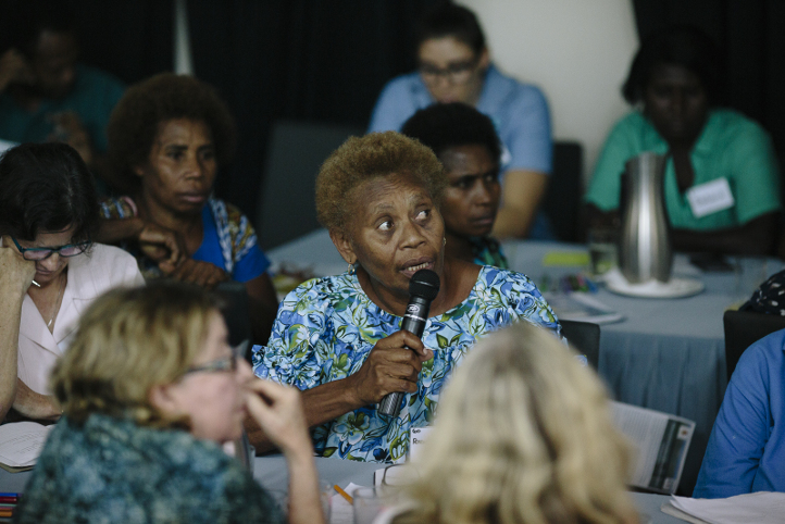
From 2015 to 2017, a multi-agency workshop team ran a series of planning workshops in ENB and WNB, with around 60 people attending each event. The idea was to bring together, in one room, decision-makers from local communities, government agencies and developers, and provide them with key information and insights into the potential outcomes of development decisions, given future uncertainty and change.
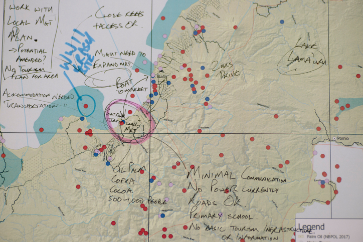
Participants were asked to map out what they valued in the landscape, the futures that they wanted, and potential changes and threats to those futures. Then they thought about what they stood to gain or lose were development to go ahead – in terms of food security, community well-being and biodiversity conservation – and how they might adjust the development to consider future uncertainty.
The aim of the workshops, says CSIRO’s Dr James Butler, was to give participants an evidence-based framework for decision-making based on a ‘ridge to reef’ systems view of the social and ecological linkages between land and sea.
“What we did, as a first step, was to try and understand how decisions are made by looking at historical developments, like oil palm, seabed mining and tourism, and figure out the process and the different decision-makers involved.
“Our aim was to first understand that complexity, and then work with it and through it to help people understand how they might make better decisions for the future, based on a ridge to reef systems view.
“It’s important to remember that this program was about the Bismarck Sea. It wasn't just about oil palm or tourism. It was getting people to think about the whole system, and how any changes in the system ultimately impact the future of the seascape.”
Rapid population growth
Dr Butler points out that while climate change is regarded as one of the major threats to New Britain’s future, the “real elephant in the room” is population growth. “From the available statistics, our estimates show that populations in the provinces are likely to double by around 2040–2045,” he says.
“That was the lightbulb moment for most of the workshop participants – realising that within 10 or 20 years, they're going to have far more mouths to feed.”
A recent program evaluation shows the workshops have had an impact, with some communities using their new political empowerment, knowledge and networking skills to more actively engage with development decisions.
For example, people from the Inland Baining LLG in East New Britain have taken a stronger stand in relation to oil palm development near their villages - development which poses a potential threat to local food security in light of rapid population growth.
Following a workshop on oil palm, the community agreed with the ENB Provincial Administration to introduce a ‘stop work’ order on unplanned oil palm plantations.
“When we held this workshop, people realised the developer had not got agreement from all the landholders and was growing oil palm in areas where some didn't want it,” says Dr Butler.
“Everyone in the workshop agreed that the development had to stop so that the community could do a proper land-use plan, and the developer could get the correct permissions before anything else went ahead.
“The land-use plan would involve everybody mapping out where the oil palm plantations could go, where the food-growing areas would be, where the conservation areas should be, how to protect water supplies, and so on.”
Further, when CEPA representatives at the same workshop became aware of the decision-making issues highlighted by the oil palm development company in Inland Baining LLG, it undertook to review its internal approval and permitting processes. Inland Baining LLG officers are also reviewing local development plans.
More time needed
TNC’s Nate Peterson, a GIS and mapping expert who worked with Dr Butler to coordinate the workshop program, says he hopes to see more women and young people at future workshops, but notes that cultural norms in PNG make this a difficult challenge.
“Our broader TNC program is charging ahead to redress gender equity, balance, and representation across all of our programs. At the moment, we have a women-focused project in PNG that is working out ways to leverage the mangrove environment for the benefit of women.”
Dr Butler says the process of building capacity and nurturing leadership in communities across ENB and WNB to make better choices and fully engage in decisions about future land- and sea-use will take time.
“You can’t change the system by doing a couple of workshops. We need to be doing the same thing for five, even ten years. In PNG, you need that sort of time before any real change in capacity and decision-making can happen.”
Apart from securing continued funding for future workshops, Dr Butler hopes to see the program secure more political support from across government so that more people from influential government agencies in Port Moresby and the provinces will be motivated to attend workshops.
“Bridging that gap between science and policy is still a major challenge.”
Gabriel J, et al (2017) ‘Oil palm development and large-scale land acquisitions in Papua New Guinea.’ In: McDonnell S, Allen M G, and Filer C, (eds) Kastom, Property and Ideology: land transformations in Melanesia. ANU, pp. 205-250.