The Port Phillip Coast Hazard Assessment project, conducted by CSIRO’s Data61 in collaboration with the Victorian Department of Land, Water and Planning (DELWP), has received the Environment and Sustainability award at both the Victorian and National APSEA Industry Awards, held separately in March this year.
The project is an assessment of the environmental effects of climate change along the Port Phillip Bay coastline, including inundation, coastal erosion, and groundwater, modelled under several different climate change scenarios.
The project has generated crucial information that can be used to plan for and manage current and future natural, cultural and economic assets, in an area that is home to more than 1.3 million Victorians, and will also be used to set state, regional and council priorities.
“We know that climate change is happening, so understanding the risks and potential hazards that could come about ahead of time is of vital importance,” said Dr Mahesh Prakash, project lead at CSIRO’s Data61.
“The Coastal Hazard Assessment has enabled us to predict which areas or assets may be vulnerable, and consider solutions in advance, rather than when it’s too late.”
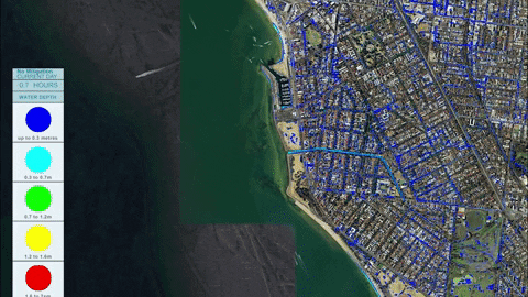
A Decision Support System (DSS), in this case a digital twin, was built using Data61’s Terria platform as part of the project, enabling planners to visualise and evaluate the impacts of coastal hazards on land under different sea level rise scenarios.
Modelling, field work and data acquisition have been integrated to ensure that the three hazards - inundation, erosion and groundwater - are projected consistently for a series of climate change scenarios.
Data61 and DELWP worked closely with 10 bay-area councils, Parks Victoria, Melbourne Water, the two Catchment Management Authorities on the Bay, the Association of Bayside Municipalities and Traditional Owners to collect myriad data and insights as part of the Assessment, resulting in the identification of hazards and their potential impact, and hazard mapping data. The Asia Pacific Spatial Excellence Awards are conducted regionally across nine locations in APAC, and celebrate the top projects and individuals across academia, government, research and the private sector. The Victorian regional awards took place on Thursday 18th March in Melbourne, with the National APSEA awards taking place on Wednesday 31st March virtually and as part of Locate2021, Australia’s premier spatial and surveying conference. For further information on the project, please visit the DELWP website.