Australia has glorious beaches that attract tourists from far and wide. But will our beaches be around to enjoy forever? Or will coastal erosion wash them into the sea to never return?
Erosion at Bribie Island in Queensland has many people asking that question. So, we’re taking a deeper dive into coastal processes that cause erosion (and deposition).
View this post on Instagram
Coastal erosion 101
Storms, swells and high tides can cause coastal erosion events and loss of land to the sea from time to time.
This can be a permanent loss of land for coastal cliffs or a temporary loss for soft sandy vegetated coasts, which can sometimes recover during calmer ocean periods.
Three things cause chronic long-term coastal erosion. Firstly, the availability of sand from offshore waters or longshore beaches and cliffs. Second, changes in coastal vegetation and manmade structures to trap sediments. And lastly, changes to waves[Link will open in a new window] and water level[Link will open in a new window] climates.
What drives coastal erosion?
Overtime, prolonged weathering from waves can remove beach sands and can cut away at cliffs and dunes and cause them to fall into the sea.
When there is not enough sediment to replace what's taken out to sea, the system becomes unbalanced. This is common in highly dynamic and soft sandy shorelines. This means the coast has has to change, and coastal erosion occurs.
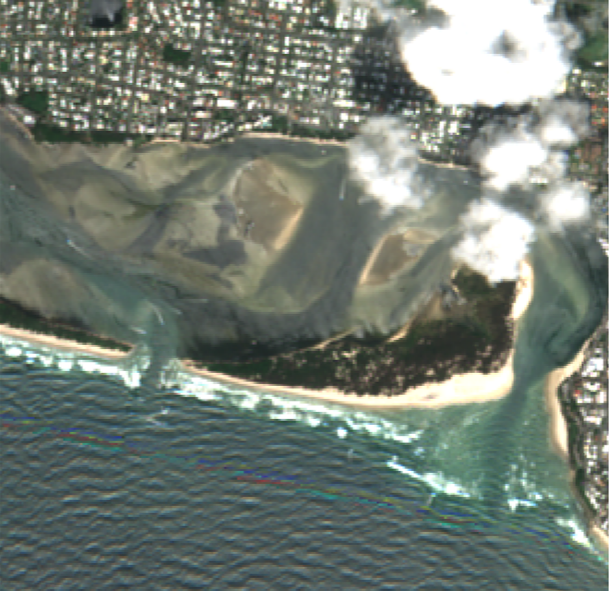
Recently, at Bribie Island the high tides and wave action from ex-tropical cyclone Seth opened a new channel at the thinnest part of the island[Link will open in a new window]. This section of island has experienced long term coastal erosion. Back in December 2020, it was weakened when ocean waves washed over it and cut through the dune.
Before and after satellite image of Bribie Island erosion.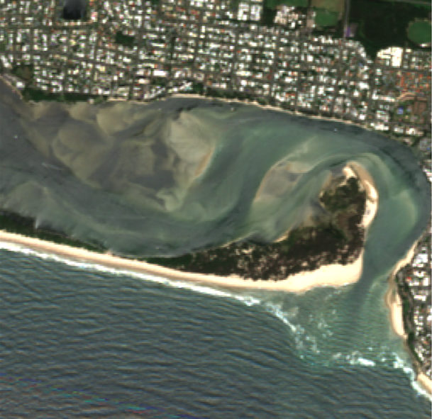
How do we measure and observe it?
Historically, researchers directly surveyed beach erosion with a theodolite (a telescopic instrument for measuring heights and angles), GPS devices and cameras (sometimes mounted on a drone) at a few beaches around Australia.
Since the early 1980s, satellites have regularly photographed the coast from space, which became free and publicly available in 2009. These images have been recently analysed for shoreline location to determine long term change detection and coastal erosion. This analysis provides a powerful tool for coastal researchers to investigate coastal change and erosion anywhere in Australia, including Bribie Island.
What are the long-term trends for coastal change in Australia?
The analysis can detect coastal erosion Hotspots[Link will open in a new window], dotted all around the nation’s coast. Researchers can use the images to count the number of eroding non-cliff coasts. We can also count the number of accreting coasts[Link will open in a new window], which are coasts that are growing from sediment deposits.
One limitation of satellite images used to measure long term shoreline change is that they have a resolution of about 15 metres. So, one pixel in the image is the footprint of a large Australian house. It therefore seems unlikely that satellites have the accuracy to detect widespread retreat from about 0.12 metres of sea level rise[Link will open in a new window] over the recorded satellite period, which may only be on the order of a few meters of retreat.
What does Bribie Island's future hold?
Bribie island has changed before, and we expect it to change into the future.
The satellite derived evidence indicates that significant coastal erosion will continue at Bribie Island. While this is alarming for the communities behind the Bribie Islands (now plural), the natural forcing of coastal change is not always that straight forward.

In the time-lapse animation of satellite images above, a large vegetation spit has formed at the northern extent of the island over the past decades. Also noticeable is a large shallow shoal of submerged sand waves is moving slowly from Moreton Island from the southeast and is heading straight for Bribie Island.
Let’s hope sands from the shoal can reach the shoreline soon to help replenish the barrier that is Bribie Island. This could help protect the coastal townships from future erosion events.
Further consideration of sediment supply from the spit and shoal is needed to identify how we can help the Bribie Islands barrier protect coastal communities now and into the future from the impacts of accelerated global sea level rise.