[Music plays, CSIRO logo and text appears: ‘Livestock Logistics Transport efficiency across northern Australia]
[Image appears of an Australian landscape and camera pans over cattle yards in the centre and then camera zooms in on the cattle]
Narrator: Known as one of the most efficient producers of cattle in the world Australia boasts more livestock than people with some 28.5 million in cattle alone.
[Text appears: ‘$12 billion industry’]
The value of this for Australia is $12 billion in off farm meat.
[Camera zooms in on the legs of the cattle running down the yards and then zooms out to show the whole of the cattle running in the yards]
But the wide open spaces that make this country so suited to cattle production also present one of the biggest challenges to an efficient production system.
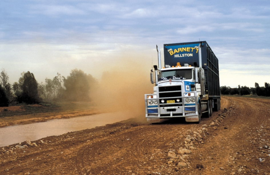
[Image changes to show cars and a cattle truck driving along the highway]
[Image changes back to the cattle in the yards]
It’s the tyranny of distance. In northern Australian more than half the cattle travel upwards of 1,000 km between production, processing and markets.
[Text appears ‘Transport up to 40% of costs’]
This makes up to 40% of the final market price placing a sizable dent in profit and productivity across the entire value chain.
[Image changes to show a CSIRO researcher working on a computer and then the camera zooms in on the Dinmore Abattoir Livestock Logistic simulation page on the computer screen]
Presented with this challenge CSIRO set out to evaluate the entire production system for livestock in northern Australia, home to 90% of the country’s live cattle export.
[Image changes to show a researcher writing on a whiteboard and then the camera zooms in on the formulas written on the whiteboard]
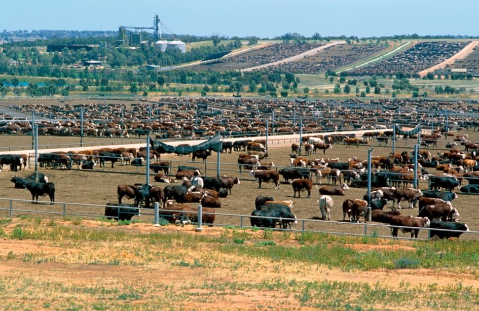
[Image changes to show a cattle feedlot and the camera pans over the feedlot]
To do this, researchers simulated more than 1.5 million vehicle movements between 50,000 enterprises over five years using some 88,000 point to point travel routes.
[Image changes to show a satellite image of the world globe and the camera zooms in on the transport networks in Northern Australia and text appears: ‘Transport Network Strategic Investment Tool, TraNSIT’]
This information was then modelled via a tool CSIRO developed know as the Transport Network Strategic Investment Tool or TraNSIT.
[Text appears: ‘Infrastructure development’]
But it’s more than Google maps for beef. It also helps to identify opportunities for infrastructure development.
[Image changes to show a large cattle feedlot and the camera pans over the landscape]
Currently most beef cattle in northern Australia need to be transported to the east coast for processing at various facilities or ports.
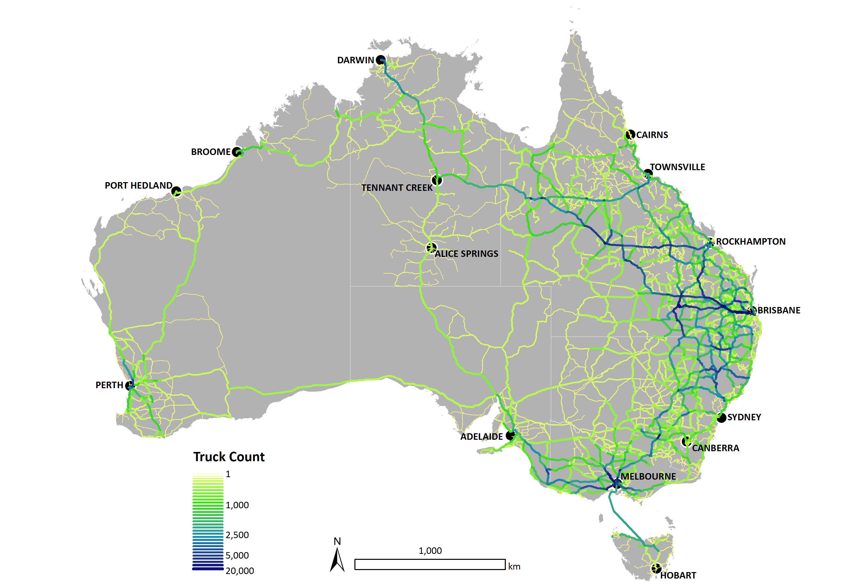
[Image changes to show a satellite image of the world globe and the camera zooms in on the colour coded transport networks in Northern Australia]
TRANSIT models these movements to show the high volume of traffic coming across the north as you can see here. If you were to develop new processing or feed lot facilities in the region closer to the cattle TRANSIT can then model the change in transport flow. As you can see now the intensity of transport on these roads has been eased.
[Image changes to show a cattle truck and text appears: ‘Animal welfare, Road safety, Reduced emissions’]
The two hypothetical facilities in this scenario could save the industry millions in transport costs. There are spin off benefits too including animal welfare, reduced driver fatigue and the impact on road safety and reduced carbon emissions.
[Text appears: ‘Policy development’]
TRANSIT is also able to contribute to policy development.
[Image changes to show a man pushing cattle up a ramp onto a truck]
Currently Queensland biosecurity requirements mean that trucks taking cattle to abattoirs need to be treated when going from tick infested zones into tick free zones.
[Image changes to show the satellite image of northern Queensland with red tick free and green tick prone zones. Text appears: ‘Up to $2.3 million savings]
You can see these movements here. TRANSIT has already shown that trucks transporting cattle from the tick prone zone highlighted in red will take longer journeys to stay within that zone to avoid the stoppage time associated with tick treatment. If biosecurity policies didn’t apply to cattle being transported to abattoirs the TRANSIT model predicts that trucks would take more direct routes which could save up to $2.3 million in transport costs from South East Queensland alone.
[Image changes to show a dark brown cow and then images flash through of fawn coloured cattle and then crops]
While the focus for TRANSIT to date has been Northern Australia, it can be applied at a national scale and not just for cattle but other commodities like grains, fibre and horticulture, or general freight, transport, even infrastructure development.
[Image changes to show a satellite image of the world globe and zooms in on Australia and then on the transport routes in Northern Australia. Text appears: ‘Music: “Soaring Together” by Anima’]
In other words TRANSIT is a decision support tool modelling a better tomorrow.
[CSIRO Australia Logo appears on the screen with text: ‘Big ideas start here, www.csiro.au’]
Cattle face some of the longest journeys of any Australian commodity—in northern Australia cattle travel an average of close to 1000 kilometres, and as much as 2500 kilometres to get to east coast abattoirs.
The new tool developed by CSIRO, called TRANSIT (TRAnsport Network Strategic Investment Tool), identifies ways to reduce travel distance and time, saving fuel costs, cutting down on wear and tear and minimising stress for both truck drivers and cattle.
“In developing this tool we completed the most comprehensive mapping of the cattle supply chain in Australia,” lead researcher Dr Andrew Higgins said.
“We can now use TRANSIT to identify key investments, large and small, at critical points in the supply chain, along with policy changes that might allow for better planning.”
As well as establishing the most direct transport routes, TRANSIT can identify the best opportunities for infrastructure and policy development, including increased access for higher productivity vehicles on some roads, and improved links to rail.
By providing a holistic view of the direct and indirect transport costs across the entire road network, TRANSIT has informed many infrastructure and policy opportunities under consideration by governments, industry and community in northern Australia.
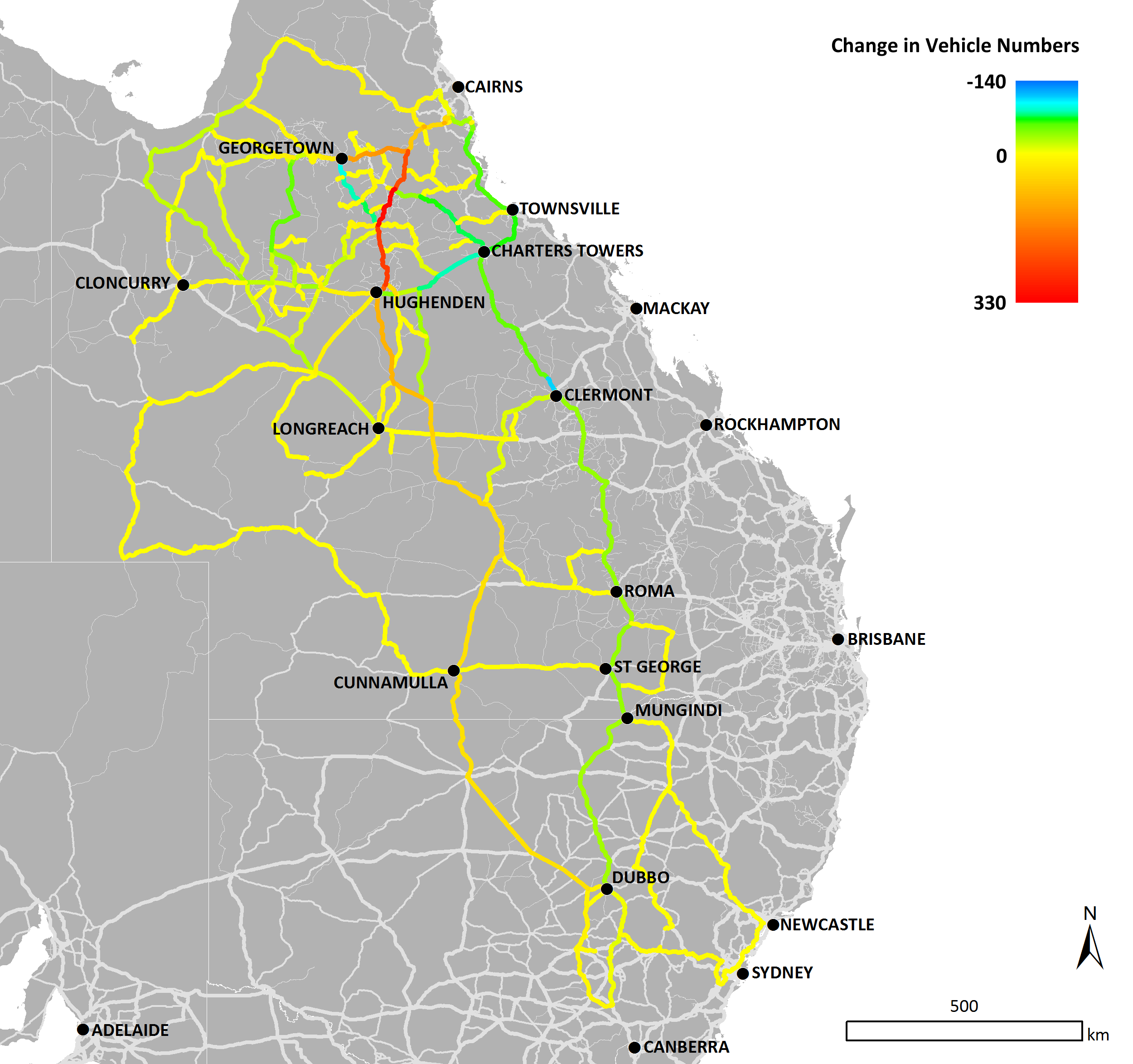
For example, TRANSIT has modelled the potential benefits of sealing the remaining 105 kilometres of the Hann Highway north of Hughenden in central Queensland.
The tool shows that this would reduce travel time on the Highway from five hours to three and a half hours, saving about 1160 hours for the estimated 1300 road trains currently using the road per year.
TRANSIT also identified that the number of road trains using the fully sealed Hann Highway would increase by 25 per cent, as it would become an optimal travel route, removing heavy vehicles from the congested coastal highways.
These benefits translate to a modelled cost saving of $1.23 million per year, plus the additional savings from shorter return journeys for empty trucks and benefits to other road users.
“Other advantages from a more efficient supply chain are improved safety and welfare of the live animals and the truck drivers themselves taking these long journeys, reduced emissions, and a more sustainable industry at a time of growth,” Dr Higgins said.
For northern Australia, the TRANSIT project takes in data on 12,000 properties, finishing farms, sale yards, feedlots, export yards, rest stops, abattoirs and ports; and 15,000 road segments (ranked according to highway, major road or minor road, sealed or unsealed, among many other factors).
The team also consulted with transport operators such as Liz Schmidt, a director of Schmidt Livestock Transport in Townsville and past president of the Australian Livestock and Rural Transporters Association.
“The TRANSIT team’s consultation with industry has been especially valuable for the ‘mum and dad’ trucking operations with limited resources," she said.
Dr Higgins said that beyond cattle, TRANSIT will now be applied to other agricultural transport, particularly degradable produce. It’s already being applied to the cattle industry Australia-wide—mapping the path of about 60,000 origin-to-destination movements representing 20 million cattle transported in Australia per year.
“It gives us a truckie’s-eye view of a supply chain, factoring in thousands of small decisions in planning routes,” Dr Higgins said.
“The beef industry has faced difficult times lately, but now there is a focus on northern Australia and all the northern states are planning for expansion.
"Our hope is that this tool can make every long journey as short as it can be, and help to expand sustainable industry.”