Solving the challenge of collecting long time-series data to monitor ocean change
The vast Southern Ocean borders Australia's southern coast and plays a significant role in the global ocean system and climate, absorbing carbon dioxide and heat from the atmosphere while providing the foundations of ocean food webs and oxygen in return. Monitoring and measuring change across this vast area of ocean presents significant challenges for ocean researchers and the global scientific community.
Project name
 Southern Ocean Time Series (SOTS) Observatory: automated moorings for climate and carbon cycle studies in the Southern Ocean
Principal Investigator
Dr Elizabeth Shadwick, CSIRO (2020 - present)
Prof Tom Trull, CSIRO (2015-2019)
Institution
Integrated Marine Observing System (IMOS)
Project duration
March 2015 - present
 (Duration shown is for time period that project has been supported by RV Investigator but monitoring commenced at SOTS site in 1998)
Overview
The Southern Ocean is an important part of the global climate system, absorbing carbon dioxide and heat to moderate the earth’s atmosphere. This vast expanse of ocean found below 30° South is estimated to be responsible for 40 per cent of the total global ocean uptake of human-induced CO2 emissions, and 75% of the additional heat that these emissions have trapped on Earth.
However, we lack long time series data to be able to monitor and measure the changes in the ocean and atmosphere in this region.
The Integrated Marine Observing System (IMOS) deep water moorings provide data that can track multi-decadal ocean change, predict regional and marine impacts, improve the understanding of the modes and drivers of climate variability in the Australian region, improve the capacity to predict ocean currents, and discover the links between ocean and climate variability, marine chemical cycling and ecosystem structure and function.
The moorings are operated through a partnership between IMOS, CSIRO, the Bureau of Meteorology and the Australian Antarctic Program Partnership (AAPP).
Project aims
The Southern Ocean Time Series (SOTS) is a facility of Australia's Integrated Marine Observing System (IMOS) and a component of the OceanSITES global network. This facility acquires ocean and atmosphere data to better monitor and quantify oceanic uptake of excess anthropogenic heat and carbon dioxide (CO2) that drives changes in ocean ecosystems via warming, stratification, acidification, and ventilation.
The data collected allows these processes to be quantified in a region where they are most intense and relatively poorly understood. The oceanic uptake of heat and CO2 varies over many timescales from daylight cycles, to daily or weekly weather events in the atmosphere, to the evolution of eddies in the ocean, and seasonal and interannual dynamics. Thus, a complete understanding of these processes requires high-frequency, and necessarily, automated observations, sustained over many years.
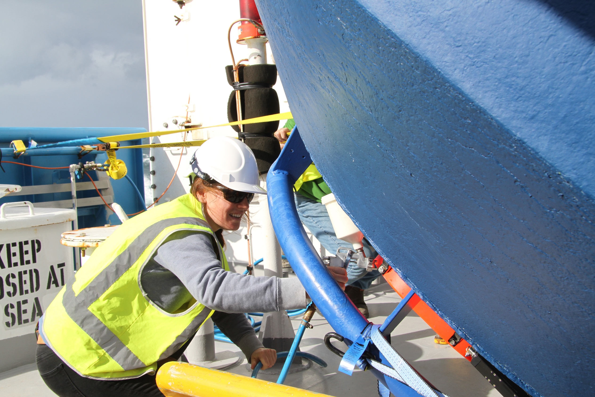
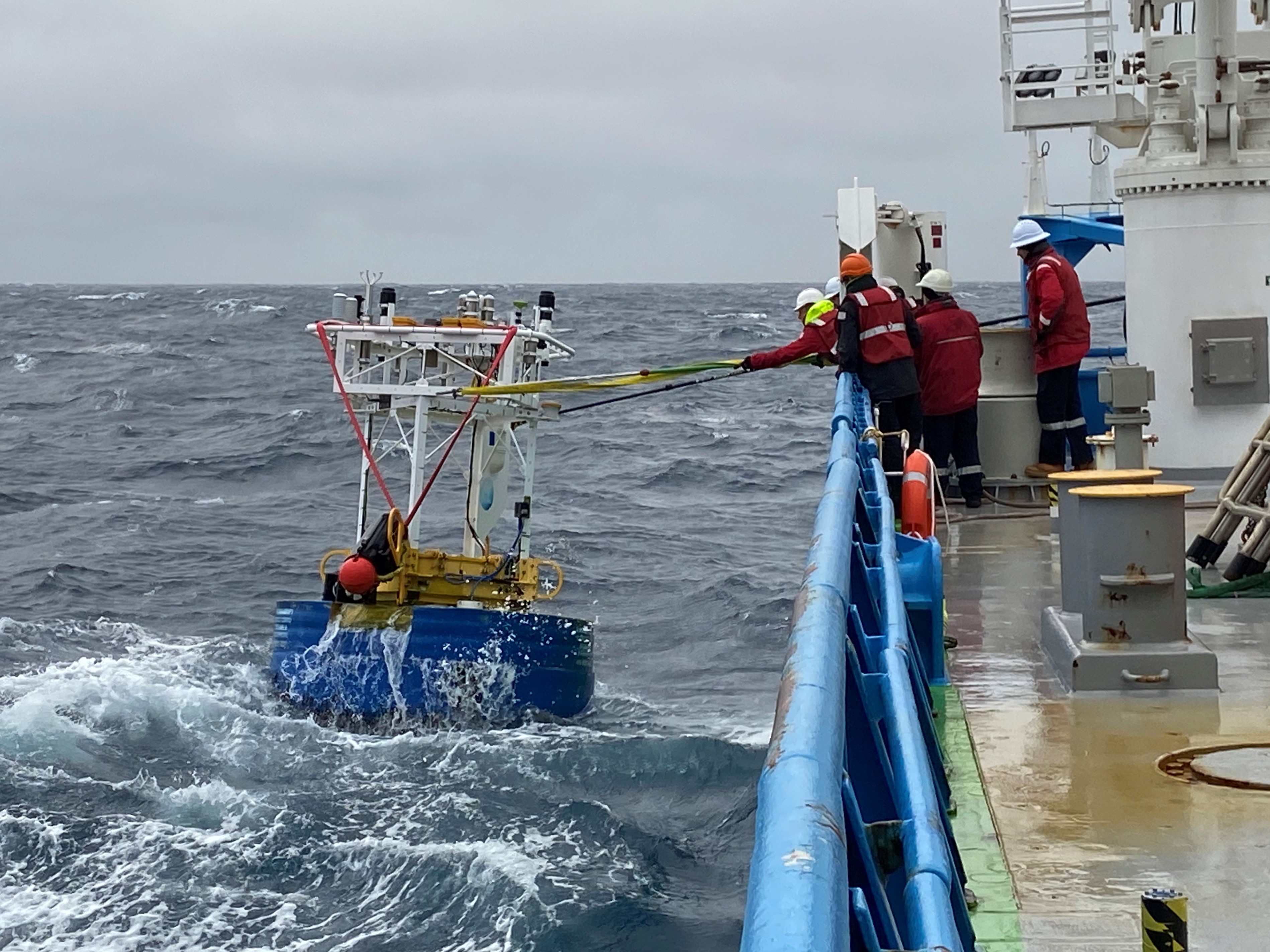 Voyages in this project service two deep-ocean SOTS moorings in the Subantarctic Zone (SAZ) southwest of Tasmania:
- Southern Ocean Flux Station (SOFS) mooring which focuses on heat, water, oxygen and CO2 fluxes across the air- ocean interface, and the physical conditions and biological processes that modulate them
- SAZ sediment trap mooring focuses on quantifying the transfer of carbon and other nutrients to the ocean interior by sinking particles also know as the biological carbon pump.
Both moorings also collect samples important to assessing ocean productivity and health, including limiting nutrients such as silicon and iron, phytoplankton functional groups, and microbial community structure via environmental DNA (eDNA).
Project results
This project commenced on CSIRO research vessel (RV) Investigator in March 2015 and has to date:
- sustained the longest time series of Southern Ocean observations operated by any nation
- contributing to the global effort to understand ocean dynamics and their role in climate and responses to anthropogenic emissions
- provided the first ever measurement of an increase in the magnitude of the ocean’s seasonal cycle of carbon dioxide.
The SOTS research improves understanding of the global climate system by focussing on a key region – the Southern Ocean. Careful sustained observations over the last decade and into the next increases our knowledge of how the ocean interacts with the atmosphere. Improved understanding is essential to enhance advice to the nation on climate variability affecting us now, develop future scenarios and impact assessments, and to make optimal decisions that will affect the nation’s future.
The work also directly addresses the issue of how ocean biogeochemistry and productivity respond to ocean dynamics, which is an important input to projecting future biogeochemical and ecosystem states. In addition, enhanced understanding of process occurring in the region related to clouds, ocean mixing, waves and rain will also lead to improved forecasts and warnings issued to the public.
We have sustained the longest time series of Southern Ocean observations operated by any nation, contributing to the global effort to understand ocean dynamics and their role in climate and responses to anthropogenic emissions. This work is part of the OceanSITES global array of time series observations which is a network within the United Nations mandated Global Ocean Observing System.
Read more about this research
Shadwick, EH, Wynn-Edwards, CA, Matear, RJ, Jansen P, Schulz, E, and Sutton AJ. 2023. Observed amplification of the seasonal CO2 cycle at the Southern Ocean Time Series. Front. Mar. Sci., 10| https://doi.org/10.3389/fmars.2023.1281854
Project voyages
The project commenced on RV Investigator in March 2015 - which was the vessel's inaugural research voyage - and has been delivered on the following voyages:
- 2026: IN2026_V03
- 2025: IN2025_V02
- 2024: IN2024_V02
- 2023: IN2023_V03
- 2022: IN2022_V03
- 2021: IN2021_V02
- 2020: IN2020_V09
- 2019: IN2019_V02
- 2018: IN2018_V02
- 2017: IN2017_V02
- 2016: IN2016_V02
- 2015: IN2015_V01
Voyage summaries, publications and project outcomes are available on each voyage page.
Acknowledgements
Australia’s Integrated Marine Observing System (IMOS) is enabled by the National Collaborative Research Infrastructure Strategy (NCRIS). It is operated by a consortium of institutions as an unincorporated joint venture, with the University of Tasmania as Lead Agent.
SOTS voyages are supported through multi-year grants of sea time on RV Investigator from the CSIRO Marine National Facility, which is funded by the Australian Government and supported by the National Collaborative Research Infrastructure Strategy (NCRIS).
Solving the challenge of collecting long time-series data to monitor ocean change
The vast Southern Ocean borders Australia's southern coast and plays a significant role in the global ocean system and climate, absorbing carbon dioxide and heat from the atmosphere while providing the foundations of ocean food webs and oxygen in return. Monitoring and measuring change across this vast area of ocean presents significant challenges for ocean researchers and the global scientific community.
Project name
Southern Ocean Time Series (SOTS) Observatory: automated moorings for climate and carbon cycle studies in the Southern Ocean
Principal Investigator
Dr Elizabeth Shadwick, CSIRO (2020 - present)
Prof Tom Trull, CSIRO (2015-2019)
Institution
Integrated Marine Observing System (IMOS)
Project duration
March 2015 - present
(Duration shown is for time period that project has been supported by RV Investigator but monitoring commenced at SOTS site in 1998)
Overview
The Southern Ocean is an important part of the global climate system, absorbing carbon dioxide and heat to moderate the earth’s atmosphere. This vast expanse of ocean found below 30° South is estimated to be responsible for 40 per cent of the total global ocean uptake of human-induced CO2 emissions, and 75% of the additional heat that these emissions have trapped on Earth.
However, we lack long time series data to be able to monitor and measure the changes in the ocean and atmosphere in this region.
The Integrated Marine Observing System (IMOS) deep water moorings provide data that can track multi-decadal ocean change, predict regional and marine impacts, improve the understanding of the modes and drivers of climate variability in the Australian region, improve the capacity to predict ocean currents, and discover the links between ocean and climate variability, marine chemical cycling and ecosystem structure and function.
The moorings are operated through a partnership between IMOS, CSIRO, the Bureau of Meteorology and the Australian Antarctic Program Partnership (AAPP).
Project aims
The Southern Ocean Time Series (SOTS) is a facility of Australia's Integrated Marine Observing System (IMOS) and a component of the OceanSITES global network. This facility acquires ocean and atmosphere data to better monitor and quantify oceanic uptake of excess anthropogenic heat and carbon dioxide (CO2) that drives changes in ocean ecosystems via warming, stratification, acidification, and ventilation.
The data collected allows these processes to be quantified in a region where they are most intense and relatively poorly understood. The oceanic uptake of heat and CO2 varies over many timescales from daylight cycles, to daily or weekly weather events in the atmosphere, to the evolution of eddies in the ocean, and seasonal and interannual dynamics. Thus, a complete understanding of these processes requires high-frequency, and necessarily, automated observations, sustained over many years.
Voyages in this project service two deep-ocean SOTS moorings in the Subantarctic Zone (SAZ) southwest of Tasmania:
- Southern Ocean Flux Station (SOFS) mooring which focuses on heat, water, oxygen and CO2 fluxes across the air- ocean interface, and the physical conditions and biological processes that modulate them
- SAZ sediment trap mooring focuses on quantifying the transfer of carbon and other nutrients to the ocean interior by sinking particles also know as the biological carbon pump.
Both moorings also collect samples important to assessing ocean productivity and health, including limiting nutrients such as silicon and iron, phytoplankton functional groups, and microbial community structure via environmental DNA (eDNA).
Project results
This project commenced on CSIRO research vessel (RV) Investigator in March 2015 and has to date:
- sustained the longest time series of Southern Ocean observations operated by any nation
- contributing to the global effort to understand ocean dynamics and their role in climate and responses to anthropogenic emissions
- provided the first ever measurement of an increase in the magnitude of the ocean’s seasonal cycle of carbon dioxide.
The SOTS research improves understanding of the global climate system by focussing on a key region – the Southern Ocean. Careful sustained observations over the last decade and into the next increases our knowledge of how the ocean interacts with the atmosphere. Improved understanding is essential to enhance advice to the nation on climate variability affecting us now, develop future scenarios and impact assessments, and to make optimal decisions that will affect the nation’s future.
The work also directly addresses the issue of how ocean biogeochemistry and productivity respond to ocean dynamics, which is an important input to projecting future biogeochemical and ecosystem states. In addition, enhanced understanding of process occurring in the region related to clouds, ocean mixing, waves and rain will also lead to improved forecasts and warnings issued to the public.
We have sustained the longest time series of Southern Ocean observations operated by any nation, contributing to the global effort to understand ocean dynamics and their role in climate and responses to anthropogenic emissions. This work is part of the OceanSITES global array of time series observations which is a network within the United Nations mandated Global Ocean Observing System.
Read more about this research
Shadwick, EH, Wynn-Edwards, CA, Matear, RJ, Jansen P, Schulz, E, and Sutton AJ. 2023. Observed amplification of the seasonal CO2 cycle at the Southern Ocean Time Series. Front. Mar. Sci., 10| https://doi.org/10.3389/fmars.2023.1281854
Project voyages
The project commenced on RV Investigator in March 2015 - which was the vessel's inaugural research voyage - and has been delivered on the following voyages:
- 2026: IN2026_V03
- 2025: IN2025_V02
- 2024: IN2024_V02
- 2023: IN2023_V03
- 2022: IN2022_V03
- 2021: IN2021_V02
- 2020: IN2020_V09
- 2019: IN2019_V02
- 2018: IN2018_V02
- 2017: IN2017_V02
- 2016: IN2016_V02
- 2015: IN2015_V01
Voyage summaries, publications and project outcomes are available on each voyage page.
Acknowledgements
Australia’s Integrated Marine Observing System (IMOS) is enabled by the National Collaborative Research Infrastructure Strategy (NCRIS). It is operated by a consortium of institutions as an unincorporated joint venture, with the University of Tasmania as Lead Agent.
SOTS voyages are supported through multi-year grants of sea time on RV Investigator from the CSIRO Marine National Facility, which is funded by the Australian Government and supported by the National Collaborative Research Infrastructure Strategy (NCRIS).
Gallery
No images found.