Ningaloo Reef in Western Australia is home to a diverse array of iconic marine wildlife, including so-called “charismatic megafauna” such as sea turtles and sharks.
The region’s beaches provide nesting grounds for three species of turtles. The waters beyond the reef host one of the world’s largest-known annual aggregations of whale sharks (Rhincodon typus), which gather off the reef between March and July.
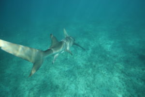
Meanwhile, the region’s shallow bays provide important nursery areas for juvenile reef sharks.
The CSIRO-BHP Billiton Ningaloo Outlook marine research partnership has been investigating the movements of turtles, reef sharks and whale sharks since 2015, tagging animals in the renowned Ningaloo World Heritage Area.
The research team has deployed more than 29 satellite tags (17 on green turtles and 12 on whale sharks) and 85 acoustic tags (40 on green turtles; 16 on whale sharks; and 29 implanted into 5 species of reef sharks).
Deploying the tags
The satellite and acoustic tags record and transmit where the animals are, allowing researchers to determine how far they travel, what habitats are most important, and how long animals are resident in certain areas. The new knowledge generated will not only improve our understanding of these species, but will help inform ways that we can look after them.

The movement of animals with acoustic tags is recorded via the Ningaloo Reef Ecosystem Tracking Array (NRETA), which forms part of the Integrated Marine Observing System Animal Tracking Facility (IMOS ATF). The tracking array has been operating since 2007 and has over 114 receivers deployed between Tantabiddi and Point Maud. These receivers record the movement of more than 500 fish, sharks, rays and turtles tagged by CSIRO since 2007.
The most recent download of 92 receivers operated by CSIRO between Tantabiddi and Turquoise Bay was completed in November 2016 with more than 5.5 million detections from 850 individual tags!
Satellite tags placed on animal’s transit a signal that is detected by satellite and allows information on the location of the turtle or whale shark to be collected in almost near-real time.
Collecting, analysing and reporting this vast amount of data provides critical information for the future management of Ningaloo, helping ensure that this unique environment and the amazing animals that live there are conserved through changing environmental, social and economic pressures.
Engaging the community
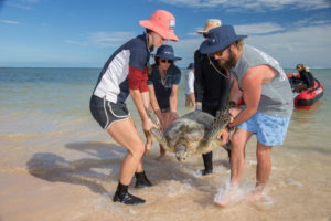
As part of the research, members of local community groups are involved, which increases their understanding of how and why research is done, and provides a way for scientists to empower the community to engage in meaningful actions. The deployment of satellite tags on green turtles at Ningaloo is undertaken with the help of Cape Conservation Group volunteers and has resulted in the collection of more than 5,000 individual location detections so far. Anybody with an internet connection can follow the turtles in near-real time through the publicly-available website seaturtle.org/tracking.
What are we finding?
We're learning that the movement of animals depends greatly on when and where they were tagged. For example, Magelica, an adult female green turtle (Chelonia mydas) tagged in May 2015 (outside nesting season) was followed for 416 days, and was last recorded only 5 km from where she was released. In contrast, Milly, also an adult female, but who was tagged on a beach during nesting season moved more than 2000 km in 223 days, and was last recorded 100 km away, near Thevenard Island.
Who needs to know?
A deep science-based understanding of the ecosystem, such as the population dynamics of mega-fauna, is invaluable input into decisions made by management agencies. For example, by knowing which habitats and places are particularly important, managers can make decisions aimed to ensure that only activities compatible with the habitats, and the animals that use them, can occur.
Want to know more? Visit www.csiro.au/ningaloo for more information about the Ningaloo Outlook project.
Dr Mat Vanderklift leads the Ningaloo Outlook project and turtle tagging.
Dr Richard Pillans leads the whale and reef shark tagging and tracking work as part of the project.