BY definition, the notion of invasive species is overwhelming, where one species, by dint of human interference, has an unnatural advantage over a finely-tuned ecosystem. How, then, do you confront an introduced species taking over thousands of square kilometres of country?
Northern Australia is vast and home to the largest intact savanna region in the world. It is across this region that the proliferation of an invasive weed is so extensive researchers are now looking to satellites to track its spread.
Gamba grass (Andropogn gayanus) was originally introduced to Northern Australia from the savannas of Africa in the 1930s as a pasture grass, but has since proliferated across approximately 15,000 square kilometres.
It has the potential to cover over 380,000 square kilometres of the Northern Australia tropical savanna, including parts of the Northern Territory, Western Australia and Queensland.
Researchers are currently working on the most efficient way to halt the spread of the invasive species, including using break-through technologies to map where it occurs and the rate at which Gamba grass is advancing across Northern Australia.
Changing the environment
Gamba grass is a perennial grass that forms dense tussocks up to 70cm in diameter and can grow up to four metres tall. It is a Weed of National Significance, and deemed a weed through Northern Australia. Its greatest threat is in the intense fires the dense biomass generates, dramatically increasing fire fuel load and posing a major threat to biodiversity and carbon storage in northern savannas.
CSIRO Principal Research Scientist and Associate Professor at Charles Darwin University Dr Shaun Levick has witnessed the dramatic ecosystem effects of Gamba grass invasion in both Brazil and Australia.
“Gamba grass is changing the behaviour of the fire regime in the tropical savanna regions it invades. Native grasses are typically much shorter and burn at a lower intensity, but Gamba can grow up to four metres tall and carries flames into the tree canopies, leading to extensive mortality,” says Levick.
The high intensity fires caused by Gamba are also a major threat to savanna burning emissions abatement initiatives in the region.
“Once it spreads and occupies dense stands, it’s incredibly hard to remove, and manual clearing and chemical spraying are expensive and time consuming work,” he says.
Fieldwork in Gamba-infested sites is formidable, the stands tower above and the wall is almost impenetrable. Fire risk is ever-present, and is a serious threat to properties and lives in rural blocks.
“We need a better understanding of its current spatial distribution and of the rate at which it is spreading to coordinate control measures.”
Modelling the landscape through lasers
Levick joined CSIRO early in 2017 and brings an international collaboration with the German Max Planck Institute for Biogeochemistry, with cutting-edge technology and computer vision methods transforming traditional field-based ecology.
He is currently working with CSIRO’s Dr Garry Cook to monitor landscapes and vegetation across Northern Australia using a remote sensing system called terrestrial LiDAR (Light detection and ranging).
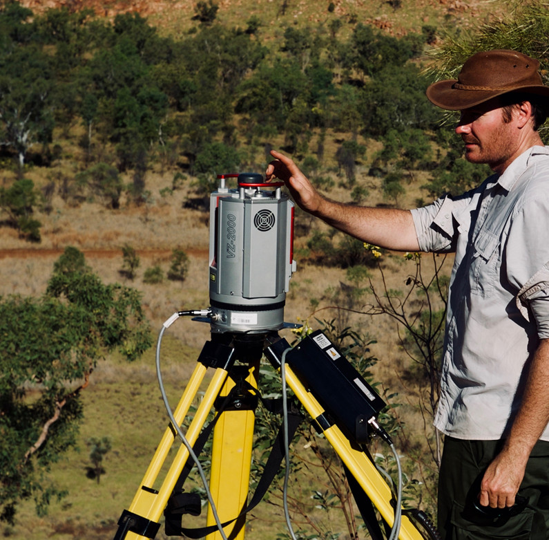
LiDAR systems can be operated from the ground, light aircraft/UAVs, and even satellites, but ground-based sensors offer by far the greatest resolution for extremely detailed reconstruction of ecosystem state.
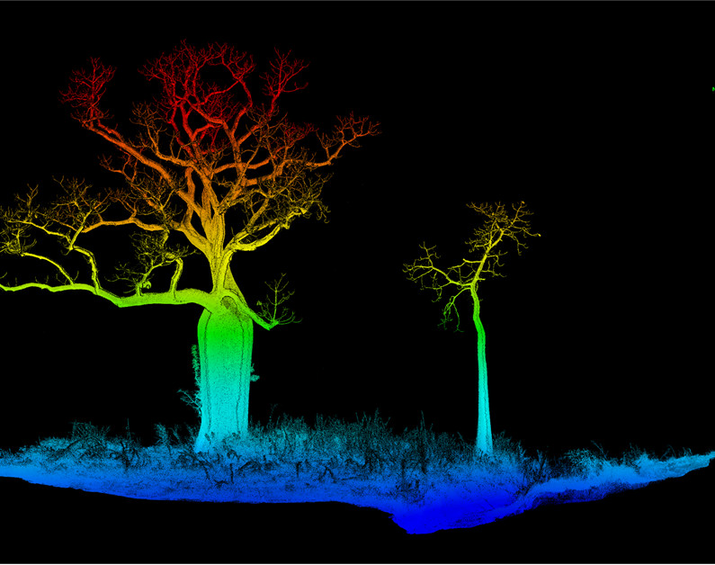
LiDAR sensors emit energy in the form of a pulsed laser that bounces off objects that it strikes to provide an in-depth 3D model of the target area up to 2,000 metres away.
LiDAR sensors produce a 3D point-cloud of the surrounding area and can be used to map the structure of terrain, trees and even Gamba grass due to its large size.
Levick says LiDAR shows good potential for monitoring the invasive species because of its high-resolution and versatility as a surveying tool compared to previous field-based methods.
The difference between LiDAR and more common optical image remote sensing systems, which capture the sunlight reflected off an object, is that the LiDAR sensor generates its own pulse of light energy, allowing for greater control of data to be collected, and operation at night.
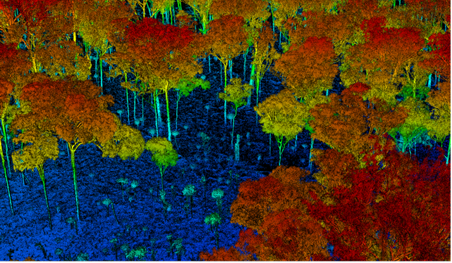
By analysing the shape of the pulse returned to the LiDAR system, researchers are able to distinguish differences in the surfaces it’s hitting from the reflective properties of the return, of which colour, shape and distance can be determined.
This data is georeferenced from a high precision GPS and provides accurate coordinates from where the data was collected, allowing researchers to accurately assess conditions in specific areas, explore changes through time, and to cross reference it with data from other sources – like satellites.
The future of LiDAR through satellites
Given the vastness of northern Australia, the only feasible approach for regular, wall-to-wall mapping of ecosystems is via satellite imagery.
Levick’s research is currently focusing on upscaling datasets to allow satellites to detect the Gamba grass through the use of RADAR remote sensing.
“We have seen some exciting developments in RADAR and optical sensors in recent years, including the current development of NovaSAR - an S-band RADAR satellite from Surrey Satellite Technology Limited that CSIRO is in partnership with,” says Levick.
Through a process known as machine learning, Levick aims to train satellites to detect the Gamba grass and provide a much-needed edge to researchers in the region where satellites can provide regular wall-to-wall datasets at regional scales.
Dr Levick says, “The terrestrial LiDAR scanner will be used to reconstruct ecosystems with varying degrees of Gamba invasion in 3D, and these models will be used to train satellite-based RADAR sensors to detect the presence of high-biomass grasses, such as Gamba.”
This process is done through modelling areas which are populated with the Gamba grass species, then overlaying it with satellite data from the same area to “teach” the satellites to recognise the structural properties of the vegetation in the landscape. This research forms part of a collaboration with Associate Professor Samantha Setterfield, from the University of Western Australia, and Dr Natalie Rossiter-Rachor, from Charles Darwin University, through the Northern Australia Environmental Resources Hub of the Australian Government's National Environmental Science Program (NESP).
“The success of any satellite mission revolves around the training and validation of space-borne measurements with ground-truthed data in the field. The high precision 3D measurements that we are collecting will prove extremely valuable in this context, and will provide critical validation of both current and upcoming spaceborne missions such as NASA’s GEDI and NovaSAR,” says Levick.
The results
He adds, the development of the multisensory modelling system is critical to the success of the project as the size of Northern Australia means that current capacities within the monitoring system are insufficient in providing the data needed to manage the species efficiently in the region.
The accuracy and scope of data provided from the LiDAR system is allowing researchers to gain a more in-depth understanding of the areas they’re monitoring and can drastically reduce the time and resources required to combat the species.
Other uses for the technology include monitoring carbon and fire management, mining legacy rehabilitation, rangeland condition assessment, and biodiversity and habitat conservation.
Read more about Shaun Levick's work via GEARS Lab.