What it's used for
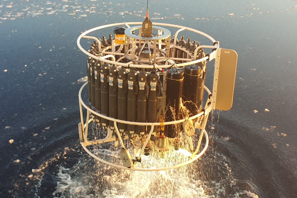 The CTD (conductivity, temperature, depth) instrument is mounted to a circular frame called a rosette and can be used to gather a range of ocean properties data including salinity, density and sound velocity.
Additional sensors can also be added to the rosette to measure other properties such as phytoplankton abundance, oxygen fluorescence and turbidity. Water bottles are also be added to the rosette to collect sea water samples.
Note that the term 'CTD' is commonly used to refer to the entire piece of equipment, including the circular frame (rosette), CTD instrument, various auxiliary sensors and water sample bottles (Niskin bottles).
How it works
The CTD is deployed over the side of the vessel to depths of 6000 m.
During ascent to the surface, the Niskin bottles can be closed at predetermined depths, allowing scientists to collect water samples at regular intervals throughout the water column for later analysis.
Key features
24 bottle carousel and frame (rosette)
A frame on which can be mounted a cluster of 24 water sample bottles and auxiliary sensors, as well as the CTD instrument.
36 bottle carousel and frame (rosette)
A frame on which can be mounted a cluster of 36 water sample bottles and auxiliary sensors, as well as the CTD instrument.
Trace metal CTD system
A specialised system that includes a trace metal clean winch with 12 bottle trace metal rosette. The system has a trace metal clean cable to 300 m which is connected to a cable that allows deployment to depths of 6000 m.
CTD deployment boom
The CTD Laboratory on RV Investigator is on the starboard side and uses a boom (extendable arm) to deploy the CTD rosette through a vertically opening hatch in the side of the ship.
VIDEO: Measuring our ocean on RV Investigator
What it's used for
The CTD (conductivity, temperature, depth) instrument is mounted to a circular frame called a rosette and can be used to gather a range of ocean properties data including salinity, density and sound velocity.
Additional sensors can also be added to the rosette to measure other properties such as phytoplankton abundance, oxygen fluorescence and turbidity. Water bottles are also be added to the rosette to collect sea water samples.
Note that the term 'CTD' is commonly used to refer to the entire piece of equipment, including the circular frame (rosette), CTD instrument, various auxiliary sensors and water sample bottles (Niskin bottles).
How it works
The CTD is deployed over the side of the vessel to depths of 6000 m.
During ascent to the surface, the Niskin bottles can be closed at predetermined depths, allowing scientists to collect water samples at regular intervals throughout the water column for later analysis.
Key features
24 bottle carousel and frame (rosette)
A frame on which can be mounted a cluster of 24 water sample bottles and auxiliary sensors, as well as the CTD instrument.
36 bottle carousel and frame (rosette)
A frame on which can be mounted a cluster of 36 water sample bottles and auxiliary sensors, as well as the CTD instrument.
Trace metal CTD system
A specialised system that includes a trace metal clean winch with 12 bottle trace metal rosette. The system has a trace metal clean cable to 300 m which is connected to a cable that allows deployment to depths of 6000 m.
CTD deployment boom
The CTD Laboratory on RV Investigator is on the starboard side and uses a boom (extendable arm) to deploy the CTD rosette through a vertically opening hatch in the side of the ship.