RV Investigator offers a platform for release of weather balloons and deployment of other airborne instruments to measure atmospheric properties.
Share
What they're used for
Weather balloons carry weather instruments that can reach the upper atmosphere, provide precise measurements of meteorological elements such as temperature, pressure, humidity, wind speed and direction. These measurements provide vital information which enhance our understanding of the climate.
Data collected from weather balloons can be used to learn about current weather conditions, and help meteorologists to make weather forecast. They can also be used for other research purposes.
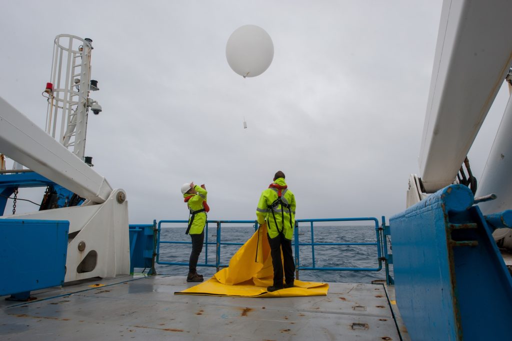
How they work
Weather balloons carry instruments called 'radiosondes': small, expendable instrument packages (weighing 200-500 grams) suspended below the weather balloon. The balloon itself is inflated with hydrogen gas.
As the weather balloon rises at around 300 m per minute, sensors on the radiosonde constantly transmit atmospheric observations and GPS position data to receiving equipment on board RV Investigator.
A typical weather balloon time of data collection (called a 'sounding') can last for two hours or more.
VIDEO: Weather radar on RV Investigator
Your video or audio is here! ID: {CB0C9768-2371-4883-ADA0-AC0E934BFF58}
What they're used for
Weather balloons carry weather instruments that can reach the upper atmosphere, provide precise measurements of meteorological elements such as temperature, pressure, humidity, wind speed and direction. These measurements provide vital information which enhance our understanding of the climate.
Data collected from weather balloons can be used to learn about current weather conditions, and help meteorologists to make weather forecast. They can also be used for other research purposes.
How they work
Weather balloons carry instruments called 'radiosondes': small, expendable instrument packages (weighing 200-500 grams) suspended below the weather balloon. The balloon itself is inflated with hydrogen gas.
As the weather balloon rises at around 300 m per minute, sensors on the radiosonde constantly transmit atmospheric observations and GPS position data to receiving equipment on board RV Investigator.
A typical weather balloon time of data collection (called a 'sounding') can last for two hours or more.
VIDEO: Weather radar on RV Investigator
[Music plays and plankton appear on screen with text: Marine National Facility]
[Camera pans over a school of southern bluefin tuna]
[Image changes to show an animation of RV Investigator]
[Text appears: RV Investigator Weather Radar]
[Camera zooms in on the weather radar and text appears: The weather radar on top of Investigator sends and receives microwave pulses.]
[Camera zooms in on the radar emitting microwave pulses]
[Text appears: The radar sends 800 pulses every second.]
[Camera zooms out on Investigator and shows the area where the radar can collect data. Text appears: Data is collected within a 150 km radius from the ship and 20 km into the atmosphere.]
[Camera pans skyward to show precipitation. Text appears: The pulse has a vertical and horizontal signal, called dual polarisation. The returning signal reveals the quantity, location, size and shape of any precipitation.]
[Image changes to show pictures of water, snow and ice. Text appears: Scientists will be able to see if a cloud is made from water, snow or ice]
[Image changes to show an aerial shot of landmasses surrounded by ocean. Text appears: Land-based radars already collect data for scientists. The radar on Investigator will record the first data from the oceans around Australia. Footnote appears: Stuart Ramsden, National Computational Infrastructure, & Todd Lane, the Centre of Excellence for Climate System Science, University of Melbourne.]
[Image changes to show weather systems moving over the landmasses and surrounding oceans. Text appears: The data will be used to improve climate models and weather predictions for Australia.]
[CSIRO logo appears with text: Big ideas start here www.csiro.au]
We have received your enquiry and will reply soon.
We're Sorry
The contact form is currently unavailable. Please try again later. If this problem persists, please call us with your enquiry on 1300 363 400 or +61 3 9545 2176. We are available from 9.00 am to 4.00 pm AEST Monday - Friday.
 What they're used for