[Music plays and text appears: Real science from caves to the classroom]
[Image changes to show computerised images of a computer game flashing past on the screen]
[Image changes to show Sally Miles – Head of Content, IntoScience]
Sally Miles: What we’re doing is we’re creating a 3D environment that’s mapped from the CSIRO technology called Zebedee, where they’re able to walk around and laser scan environments with the inter-point Cloud data.
[Image changes to show Tom Lowe from CSIRO using Zebedee inside the Jenolan Caves]
[Image changes to show computerised Zebedee image]
[Image changes back to Sally Miles]
And then we can convert that into our 3D environment where we have students with their own avatars running around learning science.
[Image changes to show computerised images of a computer game]
[Image changes back to Sally Miles]
We’re working with the Australian curriculum, which means that what the students need to be learning at school is what we’re teaching them in our activities.
[Images changes to a team of people in an office working at computers]
[Images changes to show the view from a car driving along a mountain road to the Jenolan Caves]
Robert Zlot: Jenolan Caves is in the Greater Blue Mountains World Heritage area, about three hours west of Sydney.
[Image changes to show people entering one of the Jenolan Caves]
CSIRO has been investigating 3D scanning at Jenolan since 2010, and have developed the first mobile laser mapping system for cave survey.
[Image changes to show people setting up computers in the cave]
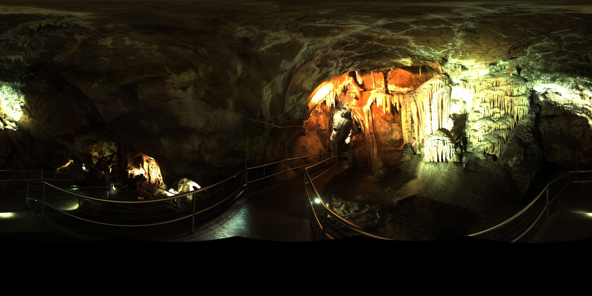
Tom Lowe: We are here to help IntoScience to create a three dimensional point Cloud, which is the three dimensional geometry of this entire cave system.
[Image changes to show a 3D computer image of the cave]
[Image changes to show Tom Lowe – CSIRO]
[Image changes to show a man setting up Zebedee]
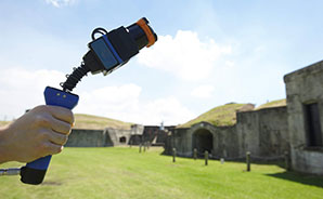
The Zebedee is a handheld device that uses laser range finding, so it uses a laser to calculate the distance to every point that it views.
[Image changes to show Tom Lowe working at a computer, and then using Zebedee]
The laser acquires roughly 40,000 points every second, and from that large collection of points we can generate a three dimensional model.
[Image changes back to Tom Lowe]
[Image changes to show Robert Zlot, CSIRO]
Robert Zlot: The concept of Zebedee was first conceived when my colleague Mike Boston and I were exploring how we might adapt technology developed for robotic vehicles to the problem of mobile cave surveying.
[Image changes to show a group of people setting up equipment in the cave]
Interestingly there’s a long history of innovation in cave survey methods at Jenolan, dating back more than a hundred years.
[Image changes to show a 3D computer image of the cave]
[Image changes back to Robert Zlot]
It’s very exciting to be a part of that story.
[Image changes back to Sally Miles]
Sally Miles: We are so excited to be working with CSIRO. We love the fact that they’ve got all of this amazing technology and we can bring that into the classroom, and we can have students experiencing these things that are you know quite new.
[Image changes to show a group of people walking into a cave]
Ben Colenso: This is a particularly challenging environment that we’re in here, and we are attempting to bring as much of that to life for students remote to the caves as possible.
[Image changes to a group of people working on equipment inside a cave]
[Image changes to show Ben Colenso – Visual Effects Supervisor, IntoScience]
The cutting edge nature of this is actually combining that technology with the hardcore science that CSIRO are delivering here, and blending those two together.
[Image changes to show a man working at a computer]
Sally Miles: In order to make it as real as possible we’re taking textures from rocks, we’re scanning them, we’re bringing them into the digital environment.
[Images changes as the camera pans over rock specimens on a desk]
[Image changes to show a man working at a computer]
[Image changes to show computer images]
[Image changes to show a man working at a computer]
So we’ve got 3D special effects artists, we’ve got people working on the digital environment to bring it all together, we’ve got the CSIRO staff, and of course we have our own science writers who will be putting the activities, and designing them into the system.
[Image changes to show two men talking in the cave]
[Image changes to show a group of people working at computers in an office]
[Image changes to show Tom Lowe using Zebedee in the cave]
[Image changes back to Tom Lowe]
Tom Lowe: It’s very exciting to be working on cutting edge technology like this, which is quite a go beyond what is currently possible.
[Image changes to a man working at a computer]
[Image changes back to Sally Miles]
Sally Miles: I loved science when I was at school, but this is a whole new level. We’re talking about kids that normally wouldn’t, you know, look twice at a science textbook. They’re going to get in and just love it.
[Text appears: We thank the Jenolan Caves Reserve Trust and acknowledge the Gundungurra and Wiradjuri people, the traditional custodians of the land]
[Image changes to show logos: Australian Government Department of Communications, 3P Learning, IntoScience, and CSIRO]
[Music plays and CSIRO logo appears with text: Big ideas start here www.csiro.au]
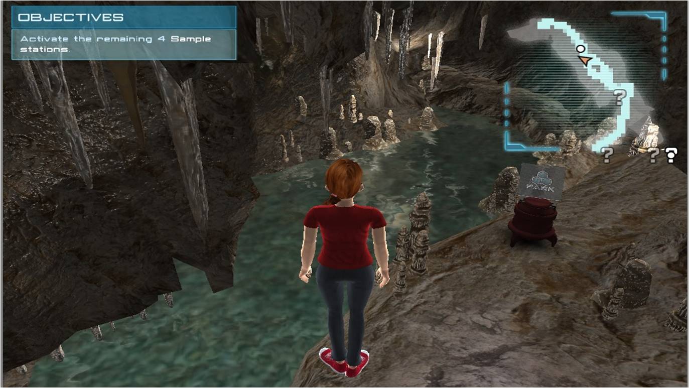
From classrooms around the country, students will embark on a digital journey exploring the iconic Jenolan Caves, an important scientific environment full of learning opportunities. As they progress through quests, the students will explore the surrounding environment and complete inquiry based learning tasks that test their core science skills.
This virtual excursion is made possible by the partnership between computer scientists from CSIRO together with science education experts from 3P Learning to develop ‘immersive learning’ environments.
It combines 3P Learning’s latest educational resource, IntoScience, with high-definition panoramic video and 3D models of real places scanned using CSIRO’s award-winning laser mapping technology, Zebedee. CSIRO’s technology is the first capable of mapping caves with lasers while continuously moving, which makes it more efficient and more detailed than traditional methods.
Acting Flagship Director, Digital Productivity and Services, Dr Michael Bruenig said that scientists from CSIRO originally became involved in scanning the Jenolan Caves to assist ANSTO with their research into cave formation processes that required three-dimensional maps of the caves.
“It’s exciting to see our cave models now brought to life as a virtual world that students can explore and perform their own scientific investigations in.” Dr Bruenig said.
Students will be able to access the caves through IntoScience, 3P Learning’s latest platform. Using their personalised avatar, they will explore the Jenolan Caves and carry out scientific investigations to discover how the caves formed.
3P Learning Managing Director, Tim Power said IntoScience, utilising technology developed by the CSIRO, have created an exciting step forward for education in Australia.
“Students have the freedom to explore and work through problem-based activities in exciting real-world environments. And we have only just begun - this innovation in learning has spectacular potential.” Mr Power said.
The 3D online education initiative will be officially launched by the Minister for Communications, the Hon. Malcolm Turnbull MP on Monday 18th August 2014.
“This fantastic education initiative enables students from across Australia to explore locations from their home or classroom, while improving their science skills along the way. It makes online excursions a reality for students who may never get the chance to visit Australia’s most iconic sites,” Minister Turnbull said.
Images
Background information
This project is funded by the Australian Government
IntoScience is a groundbreaking leap forward in secondary school science education.
For more information visit www.intoscience.com or www.3plearning.com.